

The SmartSat Cooperative Research Centre has signed a memorandum of understanding (MOU) with Australian agriculture conglomerate, Elders, to further the application of satellite-enabled Earth observation (EO) in agriculture.
The collaboration has several foci, one of which is to use satellite EO to monitor and report on emissions from Elders’ Killara feedlot, with the aim of improving environmental management.
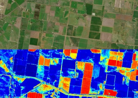
The parties will also work to apply EO for to improve the management of weeds, pests and diseases in Australian grain cropping systems.
Another aim is to develop ways to increase both the quality and quantity of yields in the Australian viticulture sector.
“This partnership with Elders underscores the importance of earth observation technology in addressing some of the most pressing challenges in agriculture,” said Professor Andy Koronios, CEO of SmartSat CRC.
“By combining space-based data with on-the-ground expertise, we can enhance environmental monitoring and sustainable agricultural and farming practices across Australia.”
Elders has been in business in the agricultural sector for 185 years, and currently works across a range of products and services, such as farm supplies, agronomy, livestock, wool, grain, finance, insurance and real estate.
“Being at the forefront of agricultural innovation allows Elders to continue providing future focused solutions for our clients, ensuring their businesses remain resilient and profitable in our fast-changing world,” added Mark Allison, Managing Director and CEO of Elders.
“To this end, we are delighted to be collaborating with SmartSat CRC to explore satellite-enabled earth observation technologies, for the benefit of Australian farmers and the wider sector.”


