

Hyperspectral sensor-equipped drones will search for abandoned fishing nets across the Groote Archipelago.
In an effort to help clear the Gulf of Carpentaria of marine debris, Charles Darwin University (CDU) will undertake a project that will use long-distance uncrewed autonomous aircraft to identify and map the distribution of ghost nets across nearly 958 kilometres of Northern Territory coastline.
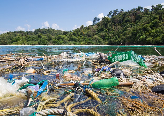
Ghost nets are abandoned, lost or discarded fishing nets, often many hundreds of metres in length that can drift significant distances across the ocean, and frequently congregating in large densities in the Gulf of Carpentaria.
The nets cause injury or death to marine animals that may become entangled in them.
CDU’s project has received funding of almost $400,000 from the Australian Government as part of the Ghost Nets Innovative Solutions Grants.
The project will use drones and artificial intelligence software routines to identify and quantify the volume of marine debris from remote and difficult to access coastlines.
Leading the project will be CDU’s North Australia Centre for Autonomous Systems (NACAS). Its Director, Professor Hamish Campbell, said the project will provide immediate environmental benefits across the Gulf of Carpentaria.
“A major challenge for ghost-net removal is that nets come ashore along vast tracts of Northern Territory coastline, which are tended to by small communities with limited resources,” Professor Campbell said.
“Consequently, ghost nets are not generally detected and retrieved for prolonged periods, if at all which increases their impact upon wildlife and raising the chances of them being re-floated and deposited elsewhere.”
Drones equipped with a high-resolution hyperspectral sensor will fly at low altitudes to survey the 45 islands within the Groote Archipelago.
AI software will be used to develop coastal aerial imagery, with NACAS partnering with CDU’s Northern Territory Academic Centre for Cybersecurity and Innovation (ACCI) on this component.
As part of the outputs of the project, abundance distribution maps illustrating the ghost-net location and size will be created and provided to the Anindilyakwa Land & Sea Rangers to assist with ghost net retrieval operations.


