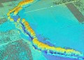
The first satellite images have arrived of the devastation left after Cyclone Marcia made landfall in Queensland over the weekend. It is believed that over 600 homes have been damaged, but damage is still being assessed.
DigitalGlobe’s Tomnod crowd-sourcing app has been opened for input to help find any damaged buildings, blocked roads, and areas of major destruction.
The platform allows any user to sift through before & after imagery of affected areas, and tagging any destruction they find. The data will presumably then be used by emergency crews to help prioritise relief and repair.
You can help out by visiting the Tomnod campaign for Cyclone Marcia here.
Similarly, Esri Australia has rolled out a web map that lists critical information on the state of the cyclone, and now serves as an archive of the path, emergency alerts issued, requests for assistance, evacuation centre locations, traffic conditions and wind speeds, as well as any pictures or videos taken from social media feeds.
The map contains authoritative data from agencies such as the Bureau of Meteorology, Queensland Fire and Emergency Services, Transport and Main Roads, and Australian Bureau of Statistics.
Mark Wallace, public safety expert at Esri Australia, said the map would help members of the public stay informed and share information.
“This is an important information source that provides a snapshot of the current status of the situation – from the aftermath of Tropical Cyclone Marcia, to the continuing storms in the south east corner,” said Mr Wallace.
“Whether it’s accessing the latest requests for assistance, or viewing pictures from affected areas – this interactive and user-friendly map will help people quickly grasp what the situation is in their communities.
“We are urging people to contribute to the map through social media, to provide their own eye-witness accounts of the situation as it unfolds.”
Members of the public can add their own updates to the map by enabling location services on their social media accounts and smartphone and using cyclone-related hashtags such as #TCMarcia.