Representatives from NASA are coming to Australia this April to share insights with the surveying and spatial community. A special session at the Locate17 Conference and Digital Earth Symposium, taking place this 3-6 April in Sydney, will showcase the latest research from NASA to support natural resource management in the face of climate change.
On Thursday, 6 April 2017, the “NASA Soil Moisture Active Passive (SMAP)” tutorial, facilitated by NASA’s Susan Moran, will promote capacity building and the use of SMAP data by the wider international community with hand-on demonstrations and practical exercises.
The NASA Soil Moisture Active Passive Observatory was launched in 2015 to provide global measurements of soil moisture at high spatial and temporal resolution. SMAP products are now available free to the public and, coincidentally, one of the first validation experiments was carried out in Yanco, NSW, Australia.

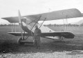
A NASA SMAP team member transports an ELBARA III radiometer, a GNSS-R reflectometer known as LARGO, as well as multi-spectral sensors in Yanco, NSW. Photo by Muhsiul Hassan, Monash University, Australia.
The session’s facilitator, Susan Moran, is chair of the SMAP Applications Working Group a member of NASA’s SMAP Science Team. Dr Moran’s research with NASA has a broad focus on the impact of global change on natural resources management and a specialised focus on the application of remote sensing to understanding hydrologic processes. Dr Moran has also served on the NASA Landsat Science Team and EO-1 Validation Team to evaluate selected technologies for meeting soil and plant science needs in the 21st Century.
Locate17’s comprehensive SMAP Tutorial will include videos, practical exercises and demonstrations. A formal report of the Tutorial to the SMAP Project will include feedback to the mission and action items for post-event follow-up. All the attendees have the opportunity be added to the SMAP Applications Working Group to receive regular messages about upcoming SMAP workshops, Cal/Val activities, and SMAP opportunities.
NASA is just one of the many conference highlights for Locate17 and Digital Earth Symposium this April. There will also be a panel discussion by Surveyor Generals from around the country and presentations about the latest technologies and spatial business opportunities.
Another special session by Dr David A. McMeekin of CRCSI will focus on “Spatial Infrastructures Technical Tutorial – Semantic Web.”
Associate Professor Allison Kealy, from The University of Melbourne, will also run a special session on the growing need for “Next Generation Ubiquitous and Trusted Positioning Systems.”
For more information and to register for the workshops, please visit the Locate Conference and Digital Earth Symposium event page.