The SEED portal now has updated habitat intactness details, as well as coastal erosion and inundation data.
NSW’s Central Resource for Sharing and Enabling Environmental Data (SEED) has released several updates of interest for geospatial professionals involved in environmental and climate change work.
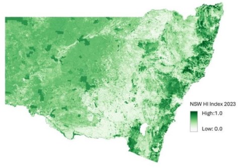
The first updates are to the Habitat Intactness and Neighbourhood Habitat Intactness indices, both of which have been refreshed with new data that takes their coverage from 2017 to 2023, and which can be found on the SEED Map.
According to SEED, “These layers support regional and state-scale reporting by providing our best state-wide estimates of habitat condition using satellite data at each 90-metre (grid cell) location across NSW”.
Specifically, Habitat Intactness measures the quality of habitats by estimating how intact they are at each location compared to a natural, unmodified state.
Neighbourhood Habitat Intactness, on the other hand, looks at how habitat loss and fragmentation affect the ability of species to move from place to place by measuring the connectivity of each location to surrounding habitats.
These data layers are used by the Biodiversity Indicator Program, State of the Environment and NSW Performance and Wellbeing reports to assess the condition of habitats and how they support native species and ecosystems across the state.
According to SEED, “This update shows Habitat Intactness increasing across NSW by nearly 1% in 2023, with improvements of 2-5% across bioregions that were most impacted by the 2019–20 bushfires and preceding drought”.
Coastal data
The other update is the addition of the NSW Coastal Erosion and Inundation Assessment 2025.
Using high-resolution seabed mapping, marine LiDAR, wave modelling and the latest sea-level rise projections from the Intergovernmental Panel on Climate Change, the dataset is “the best available statewide assessment of coastal erosion and inundation hazards under sea-level rise projections,” according to SEED.
The dataset will be of use to those involved in planning across NSW, such as local councils, the state government and other interested parties.
According to SEED, one insight from the Assessment is that “NSW’s growing exposure to coastal hazards for most asset classes begins accelerating from one to three decades”.
The data can be accessed and visualised on the SEED Map, via the Future Climate & Adaptation Hub.