Calendar

Jun
9
Mon
Open Geospatial Consortium 132nd Member Meeting @ Holiday Inn Mérida in Mérida, Yucatán, Mexico
Jun 9 @ 9:00 am – Jun 12 @ 5:00 pm
Open Geospatial Consortium 132nd Member Meeting @ Holiday Inn Mérida in Mérida, Yucatán, Mexico

The Open Geospatial Consortium’s (OGC) 132nd Member Meeting will be held from June 9 to 12, 2025, at the Holiday Inn Mérida in Mérida, Yucatán, Mexico.

The event will feature several tracks on a variety of topics, especially innovation in geospatial interoperability.

The program will highlight how remote sensing technologies such as synthetic aperture radar, LiDAR and hyperspectral sensing are contributing to societal, economic, security, and disaster response scenarios.

The program will also explore how digital transformation is improving land administration and building information management.

Jun
23
Mon
ESA Living Planet Symposium 2025 @ Vienna, Austria
Jun 23 @ 9:00 am – Jun 27 @ 5:00 pm
ESA Living Planet Symposium 2025 @ Vienna, Austria

Held every three years, the European Space Agency (ESA) Living Planet Symposium brings together diverse communities with a common interest in using Earth observation data, in a forum to meet and network with space professionals from a wide range of sectors.

Living Planet Symposium 2025 will have an emphasis on transitioning from ‘Observation to climate action and sustainability for Earth’.

The event will provide a forum to discuss the latest findings and applications based on satellite data, and to review the contribution that data and technologies have made and could further make in addressing environmental and societal challenges.

The symposium will also provide a chance for showcasing innovative products, services, missions and initiatives, with the overarching goal of demonstrating how science, society, policy-making, businesses and the economy can all benefit from observations made from space.

Aug
3
Sun
International Geoscience and Remote Sensing Symposium @ Brisbane Convention & Exhibition Centre
Aug 3 @ 9:00 am – Aug 8 @ 5:00 pm
International Geoscience and Remote Sensing Symposium @ Brisbane Convention & Exhibition Centre

The International Geoscience and Remote Sensing Symposium (IGARSS) is the flagship conference of the IEEE Geoscience and Remote Sensing Society. The 45th IGARSS will be held in Brisbane from 3 to 8 August 2025.

The theme of IGARSS 2025 is ‘One Earth,’ and the symposium will address threats to our Earth and promote collaborative global solutions that use remote sensing technology. The event will have strong technical and social programs, and present opportunities for regional and global collaboration.

Topics to be covered include:

  • The contribution of international standards for land cover and land use and guidelines for SDG reporting
  • Advanced satellite remote sensing techniques for coastal hazard monitoring and risk prediction
  • Advanced signal processing methods for geoscience and remote sensing applications
  • Applications of remote sensing in urban climate and sustainability
  • Calibration and validation of space-based imaging spectrometers during a growth era of hyperspectral data sources
  • Close-range sensing of the environment
  • Deep learning and remote sensing for rapid disaster response
  • Earth observation foundation models
  • Hyperspectral geoscience mapping in developing countries
  • New satellite laser data for terrain modelling
  • Quantum technology for remote sensing
  • Space LiDAR: Missions, technologies, and observations
Oct
15
Wed
9th International Conference on Engineering Surveying @ Brno, Czech Republic
Oct 15 @ 4:03 am – Oct 17 @ 5:03 am
9th International Conference on Engineering Surveying @ Brno, Czech Republic

INGEO 2025, the 9th International Conference on Engineering Surveying, continues the series of meetings that began in 1998.

The aim of the conference is to bring together professionals in the field of engineering surveying and other related professions, such as civil engineering, mechanical engineering, geoinformatics, geotechnics and so on, to discuss new technologies and development.

The main topics of discussion will be:

  • 3D modelling of buildings and engineering structures, BIM
  • Smart cities, data collection, sensors, ISs and IOT applications
  • Cultural heritage documentation, data collection, 3D modelling
  • Indoor navigation (SLAM, RFID, TOF, etc.), low-cost systems and applications
  • Deformation measurement, automated measuring systems
  • Industry surveys, application of modern technology for power plants, nuclear facilities, etc.,
  • Standards and quality assurance of engineering surveys
Nov
17
Mon
Free and Open Source Software for Geospatial (FOSS4G) 2025 @ Auckland, New Zealand
Nov 17 @ 9:00 am – Nov 23 @ 5:00 pm

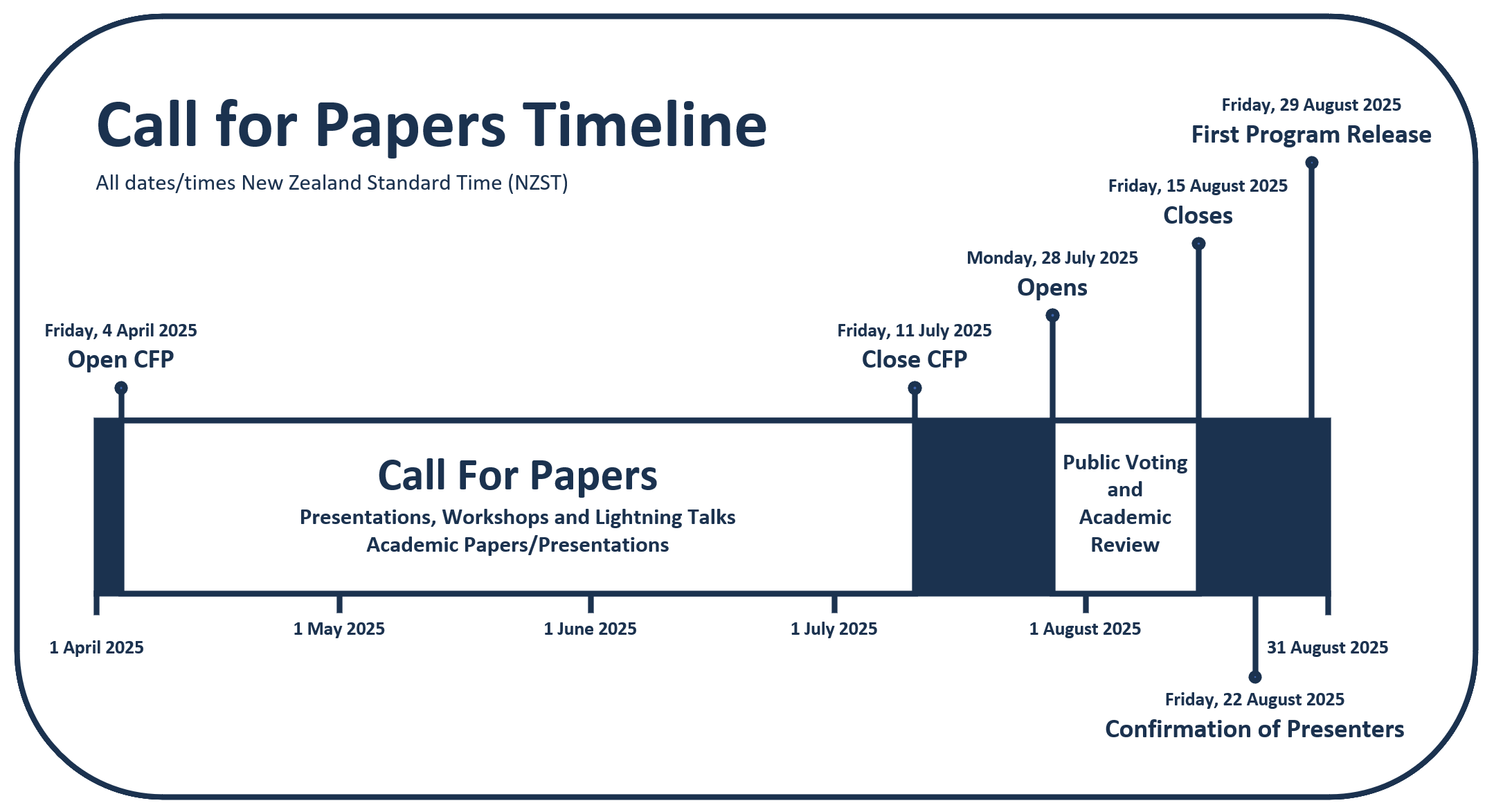
The Free and Open Source Software for Geospatial (FOSS4G) conference series, hosted in partnership with OSGeo, brings together open source geospatial users, software developers, decision makers and researchers from around the world.

The FOSS4G 2025 conference in Auckland, New Zealand, will be a vibrant gathering that fosters collaboration and celebrates innovation in the exciting world of free and open source software for geospatial.

The event will feature workshops, technical sessions, keynote addresses, ‘lightning talks,’ code sprints and community events, social events and a ‘women in geospatial’ breakfast.

It is expected that the full program will be made available in August 2025.

Newsletter

Sign up now to stay up to date about all the news from Spatial Source. You will get a newsletter every week with the latest news.

QGIS WCPS plugin for multidimensional datacubes
The new QGIS WCPS Plugin enables seamless querying and visua...
Seafloor mapping reveals landslide, tsunami risk
Surveying and mapping are providing insights into some of th...
Company behind Pokémon GO splits off spatial arm
Niantic will spin off its geospatial AI arm into a new compa...
Sphere Drones transitions to in-house production
Sphere boosts its local manufacturing capabilities to meet m...
Terria targets the digital twin universe
We speak with the firm’s co-founders to find about more ab...
Desktop, cloud geographic software
Blue Marble Geographics has launched Geographic Calculator 2...