

The 2026 Advancing Earth Observation Forum aims to bring together professionals from across Australia and beyond, to share, learn, connect and collaborate.
The four-day event promises to attract a diverse range of participants from the Earth observation community, including those in industry, government, research, defence, not-for-profits and educational institutions.
The 2026 Forum will build on the momentum generated at the 2024 event in Adelaide and the inaugural AEO Forum held in Brisbane in 2022.

LOCATE is Australia and New Zealand’s flagship geospatial event, where the region’s smartest minds meet to explore the technologies, ideas and innovations shaping our world.
Each year, leaders from government, industry, research, and emerging sectors come together to uncover the latest breakthroughs and real-world applications transforming infrastructure, environment, agriculture, energy, mining, emergency response, and urban planning.
If you want to stay ahead of spatial trends, connect with decision-makers, and be part of the conversations driving smarter, data-led futures, this is the place to be.
LOCATE26 will be held at the Melbourne Convention and Exhibition Centre from 24 to 26 November.
Organisers expect at least 1,000 people to attend, making it a not-to-be-missed opportunity for speakers to share their news and views, and for companies and organisations to promote their products and solutions to a prime audience.
Co-located with LOCATE26 will be the 2026 Digital Earth Summit, a major annual global conference of the International Society for Digital Earth (ISDE).
The ISDE has brought together global experts for more than two decades, delivering world-leading summits and symposia across 15 countries. In 2026, the combination of the Summit and LOCATE26 will bring a unique international gathering of scientists, industry innovators, educators and government leaders to Australia.
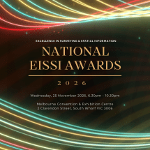
The national Excellence in Surveying and Spatial Information (EISSI) awards will be presented at a gala occasion in Melbourne on 25 November, alongside the Locate conference.
The EISSI awards represent the highest level of professional recognition within the Australian surveying profession.
The event will bring together all 2026 state EISSI category winners to compete for national honours, including national category awards and the overall national award.
The award categories are:
- Infrastructure and construction
- Extra dimension and innovation
- Community & sustainable environment
- Rural cadastral surveying & land titling
- Urban cadastral surveying & land titling
- Surveying project management
- Mine surveying
- Professional surveyor of the year
- Young professional surveyor of the year
- Professional organisation of the year (large)
- Professional organisation of the year (small)
- University project of the year
- Vocational student of the year
With a theme of ‘Strengthening and Expanding Geospatial Networks in the Pacific Islands,’ the 2026 Pacific Islands GIS & RS User Conference aims to build and enhance geospatial networks in the Pacific Islands by being a forum where experts, practitioners and policymakers can explore cutting-edge geospatial technologies and collaborations.
The conference is the largest GIS and remote sensing conference attended by Pacific Islanders, attracting more than 300 attendees every year. The event will offer a unique platform to share knowledge, strengthen regional partnerships, and drive innovation in mapping, remote sensing and spatial data infrastructure.