Each year, the Locate conference attracts hundreds of national and international delegates from within and outside the spatial, space and surveying sectors.
As Australia’s premier spatial and surveying conference, Locate provides guests with a unique opportunity to learn about the latest trends and applications in geospatial technologies.
The 2024 event will be held at the International Convention Centre at Darling Harbour in Sydney, and will include a gala evening dinner and presentation of the Geospatial Excellence Awards (formerly the Asia-Pacific Spatial Excellence Awards).
The convenor for Locate24 will be Narelle Underwood, Surveyor-General of NSW.

The New Zealand: Digital Twin 2024 Summit will explore the roadmap of digital twin systems and their impact on each stage of a project, and explore the core values, challenges and opportunities unique to the priorities of New Zealand and how digital twins can deliver them.
The event will feature real stories of success and failure, research insights, and focus not just on what has already happened but also on the potential of digital twins and where key opportunities for timely innovation appear to be.
Delegates will hear from technical experts, industry leaders and researchers in an experience designed to support the development of a dynamic and scalable digital twin ecosystem in New Zealand.

The 4th International Symposium on Applied Geoinformatics (ISAG2024), which will take place at the Wroclaw University of Science and Technology, Wroclaw, Poland, on 9 and 10 May 2024. ISAG2024 is jointly organised by the Department of Geomatics Engineering, Yildiz Technical University, Istanbul, Türkiye, Wroclaw University of Science and Technology, Wroclaw, Poland and Technical University of Crete, Chania, Crete, Greece.
The aim of the 4th ISAG is to bring scientists, engineers and industry researchers together to exchange and share their experiences and research results and discuss the practical challenges encountered and the solutions adopted in geoinformatics.
Topics to be covered include recent advances in AI, satellite imagery, advanced remote sensing, photogrammetry, image processing, global navigation satellite systems, height systems, terrestrial laser scanning, GIS, smart cities and land management.

The Geospatial World Forum is an annual gathering of geospatial professionals and leaders representing the entire ecosystem of public policies, national mapping agencies, private sector enterprises, multilateral and development organisations, scientific and academic institutions, and large end-users from government businesses and citizen services.
Geospatial World Forum 2024 will be held from 13 to 16 May in Rotterdam. Having its theme as ‘Geospatial Transition: Powering the World Economy,’ the event will showcase various facets of the ongoing transition of the geospatial industry and its existing and potential value in the world economy.
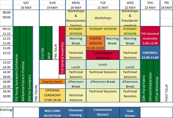
The International Federation of Surveyors (FIG) Working Week 2024 will be held in Accra, Ghana, from 19 to 24 May. The event is being held in cooperation with the two national associations: the Licensed Surveyors Association of Ghana (LiSAG) and the Ghana Institution of Surveyors (GhIS).
The event will comprise the following:
- Conference: 20-22 May
- FIG General Assembly: 19 and 23 May
- Pre- and post-events: 18-19 and 23 May

The FIG Working Week will be a week-long celebration of innovation and collaboration that unites the global community of surveying and spatial professionals, providing an opportunity to bridge the gap between science and the policymakers and stakeholders who drive real-world change.
The event will provide attendees the opportunity to:
- Immerse themselves at the forefront of geospatial technology and sustainable resource management.
- Elevate their expertise through hands-on workshops, interactive sessions, and thought-provoking discussions.
- Connect with like-minded professionals, experts and decision-makers from around the world.
The FIG Working Week 2024 is expected to attract more than 1500 attendees from around 80 countries, to participate in 70-plus presentation sessions and networking opportunities, and to experience a comprehensive trade exhibition.

The ROTORTECH Helicopter and Uncrewed Flight Exposition is the premier industry event for the Helicopter/Rotary Wing and RPAS/UAV/eVTOL community in Australia, New Zealand and the Indo-Asia-Pacific region.
Held by AMDA Foundation with input from major industry supporter the Australian Helicopter Industry Association, ROTORTECH 2024 will provide a vital interface between industry, regulators and government, including:
- Operations and safety presentations
- Industry conferences
- Manufacturers technical workshops
- Industry exposition showcasing the products and services of helicopter and uncrewed flight related companies
ROTORTECH 2024 will host conferences by the AHIA and Australian Association for Uncrewed Systems (AAUS) and feature presentations by key rotary and uncrewed flight industry experts from Australia and the Indo-Asia-Pacific region.

The ISPRS Technical Commission II ‘Photogrammetry’ focuses, at various scales, on geometric, radiometric and multi-temporal aspects of the image- and range-based 3D surveying, mapping and modelling in the age of AI and mixed reality.
The organisers of the June 2024 Symposium welcome researchers, practitioners and companies involved in photogrammetry and computer vision to present and discuss their results with a broader audience. The Symposium will feature four days of plenary and keynote talks, along with parallel sessions of oral and poster presentations from academia and industry.
The symposium’s theme is ‘The Role of Photogrammetry for a Sustainable World,’ emphasising machine learning and mixed reality. The event is being organised in collaboration with ASPRS (American Society of Photogrammetry and Remote Sensing) and SGPF (Swiss Society of Photogrammetry and Remote Sensing).
Image credit: ©stock.adobe.com/au/Lifes_Sunday

The 9th International Conference on Cartography and GIS will take place in Nessebar, Bulgaria from 16 to 21 June 2024. The ICCGIS is a biannual conference that began in 2006 and has been held every two years since (except for 2020). In total, the Conference has attracted attendees from more than 60 countries and has published more than 700 scientific papers in its proceedings.
The aim of the conference is to collect knowledge and share experiences about the latest achievements in the field of cartography and GIS. Multiple parallel events will take place during the conference, including annual meetings of ICA commissions and a special ISDE plenary session. There will also be a Seminar on Disaster Risk Reduction – Solutions and Innovations.

The Geospatial Council of Australia’s World Hydrography Day Seminar will dive deep into the latest advancements in hydrographic surveying, mapping technologies and data analysis techniques.
The event will give delegates the opportunity to connect with fellow professionals, share experiences and learn from industry leaders at the forefront of marine charting and exploration.
For both seasoned experts and those just starting out in the field, the event promises invaluable insights and networking opportunities to enhance skills and advance careers.
Image credit: ©stock.adobe.com/au/HENADZ

In 2024, the International GNSS Service (IGS) will celebrate 30 years of operational service, having commenced on 1 January 1994.
The University of Bern together with the partners from the CODE consortium — AIUB: Astronomical Institute of the University of Bern; swisstopo: Swiss Federal Office of Topography; BKG: Federal Agency for Cartography and Geodesy, Germany; IAPG/TUM: Institute for Astronomical and Physical Geodesy, Technical University of Munich — invites the GNSS community to celebrate the IGS’ third decade with a symposium and workshop in Bern, Switzerland.
The in-person event is planned for the week from 1 to 5 July in 2024 and will take place in two parts: symposium (1-4 July) and workshop (4-5 July).
The IGS is a service of the International Association of Geodesy (IAG), its Global Geodetic Observing System (GGOS), The International Union of Geodesy and Geophysics (IUGG), and a network member of the International Science Council (ISC) World Data System (WDS).


