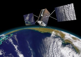
The IGNSS Association’s biennial international GNSS conference will return to UNSW Sydney from 7 to 9 February, 2024, where it will celebrate the first half-century of GNSS and look ahead to the next 50 years.
IGNSS 2024 will bring together experts, policy makers and emerging leaders from across the globe to examine the latest advances, present cutting edge research and discuss policy, market development and infrastructure.
The conference will also showcase Australia and New Zealand’s Southern Positioning Augmentation Network (SouthPAN), along with developments by other countries across the Asia-Pacific.
Topics to be covered at the conference will include:
- Autonomy on land, air, sea and in space
- Aviation and avionics
- Cooperative Intelligent Transport Systems
- Machine guidance applications in agriculture, construction and mining
- Maritime applications
- Uncrewed aerial systems
- Space applications of PNT in Earth orbit and for lunar and Martian exploration
- Positioning infrastructure
- GNSS vulnerability, resilience and risk
- Interference detection and mitigation
- Policies and standards
- SBAS and other augmentations
- Datums and geodesy
- National and international GNSS developments
- Emerging application areas for GNSS
- Key industries and their reliance on GNSS
- The multi-GNSS era
- Cyber security in PNT applications and infrastructure
- Alternative PNT
- State of the art in PNT algorithms and software development
- GNSS aiding and sensor fusion
- Positioning in GNSS denied environments
- Development of GNSS receiver hardware and firmware
- Precise position using smartphones
The organisers are encouraging early career researchers and industry representatives to present their work. The abstract submission process will open soon — keep an eye on the IGNSS website for announcements.
Image courtesy Lockheed-Martin

The annual Geo Connect Asia Show & Conferences offers a two day, in-person meeting place for ASEAN’s vibrant geospatial community. Bringing geospatial solutions to the heart of decision-making the event combines with technologies from the digital construction, drone and remote sensing markets.
Geo Connect Asia looks to host its ASEAN neighbours and build on a vibrant community as new technologies add new application tools to enable the Industry 4.0 Revolution. The emergence of AI, blockchain, IoT, robotics and UAVs create a new dynamic and platforms for a region well equipped to take on the challenges ahead.

The 2024 edition of the International Conference on Geographical Information Systems Theory, Applications and Management (GISTAM 2024) aims to create a meeting point of researchers and practitioners that address new challenges in geo-spatial data sensing, observation, representation, processing, visualization, sharing and managing, in all aspects concerning both ICT as well as management information systems and knowledge-based systems.
The conference welcomes original papers of either practical or theoretical nature, presenting research or applications, of specialised or interdisciplinary nature, addressing any aspect of geographic information systems and technologies, such as:
- Data acquisition and processing
- Remote sensing
- Interaction with spatial-temporal information
- Spatial data mining
- Managing spatial data
- Modelling, representation and visualisation
- GIS and climate change
- Domain applications

The 4th International Symposium on Applied Geoinformatics (ISAG2024), which will take place at the Wroclaw University of Science and Technology, Wroclaw, Poland, on 9 and 10 May 2024. ISAG2024 is jointly organised by the Department of Geomatics Engineering, Yildiz Technical University, Istanbul, Türkiye, Wroclaw University of Science and Technology, Wroclaw, Poland and Technical University of Crete, Chania, Crete, Greece.
The aim of the 4th ISAG is to bring scientists, engineers and industry researchers together to exchange and share their experiences and research results and discuss the practical challenges encountered and the solutions adopted in geoinformatics.
Topics to be covered include recent advances in AI, satellite imagery, advanced remote sensing, photogrammetry, image processing, global navigation satellite systems, height systems, terrestrial laser scanning, GIS, smart cities and land management.
The International Federation of Surveyors (FIG) Working Week 2024 will be held in Accra, Ghana, from 19 to 24 May. The event is being held in cooperation with the two national associations: the Licensed Surveyors Association of Ghana (LiSAG) and the Ghana Institution of Surveyors (GhIS).
The event will comprise the following:
- Conference: 20-22 May
- FIG General Assembly: 19 and 23 May
- Pre- and post-events: 18-19 and 23 May
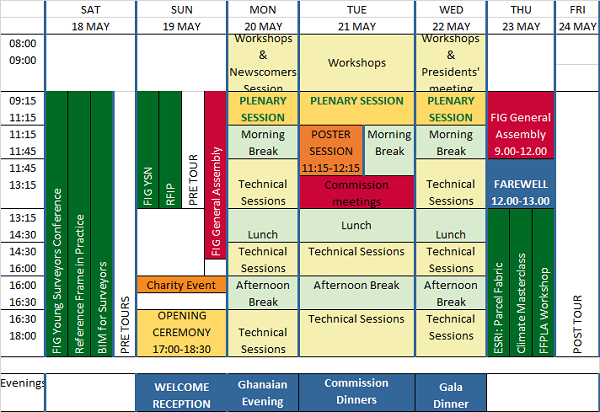
The FIG Working Week will be a week-long celebration of innovation and collaboration that unites the global community of surveying and spatial professionals, providing an opportunity to bridge the gap between science and the policymakers and stakeholders who drive real-world change.
The event will provide attendees the opportunity to:
- Immerse themselves at the forefront of geospatial technology and sustainable resource management.
- Elevate their expertise through hands-on workshops, interactive sessions, and thought-provoking discussions.
- Connect with like-minded professionals, experts and decision-makers from around the world.
The FIG Working Week 2024 is expected to attract more than 1500 attendees from around 80 countries, to participate in 70-plus presentation sessions and networking opportunities, and to experience a comprehensive trade exhibition.

The annual conference of Survey and Spatial New Zealand (S+SNZ) will take place in August in Napier, on the east coast of New Zealand’s North Island.
Napier was the epicentre of destruction wrought by Cyclone Gabrielle in 2023, so the theme for the 2024 event is ‘Looking Ahead in the Heartland,’ which S+SNZ says, refers “not just to the optimism and resilience of provincial New Zealand, but also provides an opportunity to discuss approaches to the challenges of climate change and disaster recovery around the country”.
Super-early bird registration is now open.

The complexities of understanding and forecasting evolutionary processes necessitate geographic modelling and simulation, which have emerged as potent tools for addressing critical issues such as climate change and sustainable resource use. But there is a pressing need for an open geographical modelling and simulation framework. Such a framework would serve as a catalyst, attracting more scholars and encouraging their collective efforts to address geographic challenges.
This workshop is designed to explore pertinent theories, approaches and potential applications, while fostering communication among experts from diverse domains. Its primary objectives include stimulating extensive discussions regarding the potential directions of the field and promoting further research, thus paving the way for a promising future in collaborative geographic modelling and simulation.
Organisers:
- School of Geography Science, Nanjing Normal University, China
- Key Laboratory of Virtual Geographic Environment (Ministry of Education of PRC), Nanjing Normal University, China
- International Geographical Union – Modeling Geographical Systems Commission
Co-organisers:
- International Environmental Modelling and Software Society
- The International Association of Chinese Professionals in Geographic Information Sciences
- Geographic Model and Geographic Information Analysis Commission, The Geographical Society of China
- Working Group on Education and Capability Building for Digital Earth, International Society for Digital Earth
- Jiangsu Center for Collaborative Innovation in Geographical Information Resource Development and Application, China
- National Earth System Science Data Center – Yangtze River Delta Subcenter
- School of Environment, Nanjing Normal University
Important dates:
- Abstracts due: 20 August 2024
- Early-bird registration ends: 31 August 2024
GISTAM 2025, the 11th International Conference on Geographical Information Systems Theory, Applications and Management will be a meeting point of researchers and practitioners that address new challenges in geospatial data sensing, observation, representation, processing, visualisation, sharing and management.
This includes all aspects of information communication and technologies as well as management information systems and knowledge-based systems.
The conference will present original contributions of either practical or theoretical nature, including research and applications of specialised or interdisciplinary natures, addressing different aspects of geographic information systems and technologies.
Topics to be covered include:
- Data acquisition and processing
- Remote sensing
- Interaction with spatial-temporal information
- Spatial data mining
- Managing spatial data
- Modelling, representation and visualisation
- GIS and climate change
- Domain applications
Deadlines:
- Regular Paper Submission: 13 December 2024
- Abstracts Track Submission: 30 January 2025

The Geo Connect Asia Show and Conference has scaled up from its launch in 2020 to become the regional meeting place for the fast expanding geospatial, positioning, digital construction and remote sensing markets.
With the growing application of geospatial based knowhow in decision-making across government, enterprise and non-profit the annual event comprises a show with a mix of thought leadership and technical platforms.
Last year’s event attracted more than 100 leading companies and 2494 visitors. Its co-location with Drones & Uncrewed Asia both presents the global UAV industries, but also addresses the importance of data acquisition and analytics in critical and emerging vertical markets.
Digital Construction Asia adds particular focus on the development of one of the region’s largest industries.
The addition of Marine & Hydro Asia expands the reach into the region’s hydro-marine data markets, which are so critical to the economy and security of Southeast Asia.


