

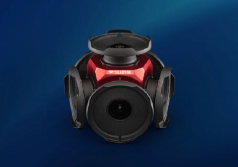
C.R. Kennedy has announced that it is now the exclusive distributor in Australia of the Teledyne Ladybug6 high-accuracy 360-degree camera.
The Ladybug6 is designed to capture spherical images from moving platforms, and is able to do so in all-weather conditions due to its industrial-grade design.
Suitable customer applications include panoramic street image production, road surveying, asset inspection, feature extraction for HD map generation, and it is fully compatible with laser mobile scanning systems from Leica, Riegl, Trimble and others.
Out-of-the-box factory calibration combined with global shutter CMOS sensors produces 72 MP images with pixel values that are spatially accurate within +/- 2 mm at a distance of 10 metres.
The Ladybug6 captures, compresses and transmits 8-bit or 12-bit pixel data with onboard image processing for optimised workflows. The software development kit enables image acquisition, spherical and panoramic image production, and fine grain control of pre- and post-acquisition settings via an interface. In addition, the camera’s APIs, combined with hardware inputs, enable precise setting and trigger controls.
“The Ladybug6 is an ideal complimentary component to our existing Leica Pegasus TRK mobile laser scanners, as well as for other makes. Our geospatial customers demand the best, and they’ve been astounded by the incredible image quality, fast acquisition speeds, and ease of use,” said Sam Hesper, National Manager of mobile laser scanning systems at C.R. Kennedy & Company.


