

The European Space Agency’s Biomass satellite has rocketed into orbit aboard a Vega-C launch vehicle, on its way to map the Earth’s forests.
The launch took place at Europe’s Spaceport in French Guiana at 7:15pm AEST on 30 April 2025.
Biomass is ESA’s latest Earth Explorer mission and is intended to “provide vital insights into the health and dynamics of the world’s forests, revealing how they are changing over time and, critically, enhancing our understanding of their role in the global carbon cycle,” according to ESA.
“I’d like to extend my congratulations to everyone who has been involved in developing and launching this extraordinary mission,” said ESA’s Director of Earth Observation Programmes, Simonetta Cheli.
“Biomass now joins our esteemed family of Earth Explorers – missions that have consistently delivered groundbreaking discoveries and advanced scientific understanding of our planet.
“With Biomass, we are poised to gain vital new data on how much carbon is stored in the world’s forests, helping to fill key gaps in our knowledge of the carbon cycle and, ultimately, Earth’s climate system.”
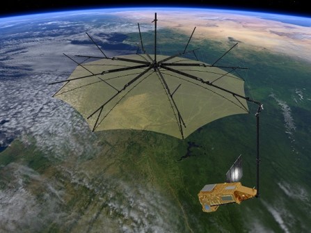
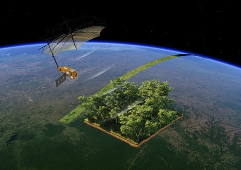
The satellite is the first to carry a fully polarimetric P-band synthetic aperture radar, featuring an unfolding 12m-wide mesh antenna, which will be used for interferometric imaging.
The radar’s long wavelength of around 70 cm will enable it to penetrate the forest layer and measure the ‘biomass,’ comprising woody trunks, branches and stems, which is where trees store most of their carbon.
The question Biomass is poised to answer, is just exactly how much carbon is stored in forests and how that is changing over time under the influence of deforestation, a warming climate and increasing atmospheric carbon dioxide levels.
The 1,250kg satellite will do its work from a Sun-synchronous, near circular, dawn-dusk orbit of altitude 666 kilometres.
The mission will be conducted in two phases — the tomographic phase and the interferometric phase.
According to ESA, the tomographic phase is “comparable to a CT scan which combines several images to reveal information of the inner structure of a forest”. This first phase will take about 18 months and will result in a single worldwide map.
The tomographic phase will produce 3D data at 15- to 20-metre vertical resolution and a horizontal resolution of 200 metres.
The interferometric phase will then begin and will last for around four years. Under this phase, initial snapshots will be made of each area of forest canopy and density, and then the same areas will be revisited four times to enable changes in forest height and above-ground biomass to be calculated and monitored.


