Japanese artist Isao Hashimoto has created a beautiful, undeniably scary time-lapse map of the 2053 nuclear explosions that took place between 1945 and 1998, beginning with the Manhattan Project's "Trinity" test near Los Alamos, and concluding with Pakistan's nuclear tests in May of 1998. This leaves out North Korea's two alleged nuclear tests in this past decade (the legitimacy of both of which is not 100% clear). It’s a sobering documentation of man-kind’s most devastating invention.
Do you consider yourself a geogeek? Is that a positive or negative term in our industry? What about outside our industry? Do you have a definition for it? Directions Magazine Executive Editor Adena Schutzberg looks at the term “geogeek” and how it’s used around the Web.
Google Maps Mania’s 'maps of the week' include MyHistro, which is a handy way to create timelines on Google Maps – whether it’s your latest holiday adventure, or the life of Marilyn Monroe.
Also featured is Uncharted.fm, which hekps you learn all about the locations of and background info on the countries of the world.
There is also a Resident Evil zombie hunting game based in Google’s Street view. Something for everyone, this week.
Also featured is Uncharted.fm, which hekps you learn all about the locations of and background info on the countries of the world.
There is also a Resident Evil zombie hunting game based in Google’s Street view. Something for everyone, this week.
Speaking of time-series’, GIS Lounge has a post that describes some different ways to represent time on a map.
The ESRI blog has a map that allows you to view the locations on the red planet of all four Mars rovers, including the latest-and-greatest Curiosity.
Following on from coverage in Wired, LiDAR News alerts readers to a new project put together by a group of robotics researchers in Sweden called Kinect@Home, which is crowdsourcing the capture of every day objects in 3D using a plugin for your Xbox 360’s Kinect. Very interesting.
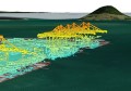
LiDAR News also points us to a virtual tour of the Maeshowe tomb in Scotland – a stone mound 35 metres across and older than most of the pyramids. It’s pretty amazing what LiDAR can do.
You often hear the term ‘Big Data’ thrown around. But what does it really mean? And, for that matter, what happened to create it? O’Reilly Radar has a post that talks about the creation of Big Data, and what lies in store in the future.