Watch the chilly 2018 Winter Olympics from space

An image of the stadium in PyonChang where the opening ceremony for the 2018 Winter Olympic Games was held, captured by DigitalGlobe’s WorldView 3 satellite.
Geoawesomeness
Can’t get to the 2018 Winter games — too cold, too far? Enjoy these images of PyeongChang captured from orbit.
Unpleasant Design in Disguise: Bike Racks & Boulders as Defensive Urbanism

Sitzkiesel” (“sitting-pebble”) replacing a former bench in the Kleiner Tiergarten park in Berlin, Germany by Fridolin Freudenfett, licensed under CC BY-SA 4.0.
99 percent invisible
99 percent invisible highlights some of the insidious design and planning strategies that reinforce class divisions or close down public space to the underprivileged, under the guise of incresing public utility.
Places in Civil War History: The Anaconda Plan and Union Victories in Tennessee

“Scott’s great snake Entered according to Act of Congress in the year 1861.” J.B. Elliott, 1861. Image provided by Geography and Map Division, Library of Congress.
Worlds revealed: geography and maps at the Library of Congress
Tim St Onge explores a series of historical maps related to significant events in the American Civil War.
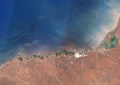
Troubling images reveal how Cape Town ran out of water

NASA’s Earth Observatory has captured the dramatic draining of Cape Town’s reservoirs. Image provided by NASA.
Satellite data reveals the alarming extent of Cape Town’s water crisis.
Revealed: Dutch are least hygienic Europeans

A Gallup poll has revealed some grubby truths about hygeine habits in Europe. Image: BigThink Strange Maps blog.
Big Think: Strange maps blog
How would you fare in Gallup’s hand-washing poll?