

This article was first published in Issue 123 (Feb/Mar 2023) of Position magazine.
Toitū Te Whenua Land Information New Zealand (LINZ) and City Rail Link Limited (CRLL) are collaborating to ensure the integrity of ownership and protection of not only the railway stations and tunnel infrastructure along Auckland’s new City Rail Link (CRL), but also the subsoil surrounding the infrastructure.
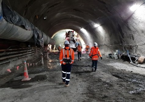
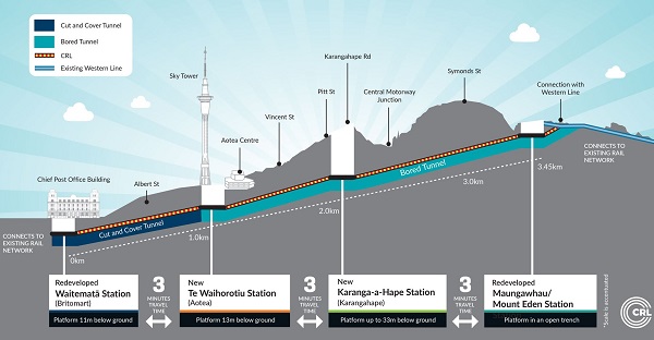
The CRL, established by the New Zealand Government and Auckland Council, will comprise a 3.45km twin-tunnel underground rail link up to 42 metres below Auckland City, linking Britomart to Mount Eden. It will eventually accommodate up to 54,000 passengers per hour at peak travel times.
The collaboration between LINZ and CRLL aims to ensure that future use of the land and subsoil, be it private or public property, or road, is minimally impacted by the tunnel and rail stations.
LINZ Principal Cadastral Surveyor, Mike Morris, says the CRL survey is not without its challenges.
“The magnitude of the project is not so much the huge quantity of data coming through, but the complexity of the information which makes it such a significant project,” he said.
“New Zealand was ground-breaking in its introduction of a two-dimensional cadastre in the early 2000s; the current redesign of the system, Landonline, is the start of a journey to a fully 3D land information system.”
Light at the end of the tunnel
Rick Galli, CRLL Head of Property, says the collaboration project has only just commenced and will be a long journey.
“Geo-referencing in 3D is really exciting and it will be fascinating to see where LINZ is going with it,” he said.
Both public entities share a duty of care to look after New Zealand’s land and environmental resources, so they are sustained for future generations.
“Land and property are finite resources requiring protection to ensure their use can be maximised, which is also a key purpose of LINZ,” said Galli.
“CRLL has engaged with LINZ across multiple points in the project, including acquisition under the Public Works Act, willing purchase negotiations, the naming of rail stations (through the New Zealand Geographic Board), meeting survey standards and ensuring the Cadastral Survey Datasets are compliant and fit for purpose.”
According to Morris, “historically, the amount of rework required to achieve compliance with the required survey standards is high, and the more complex the surveys, the more difficult it is to achieve first-time compliance”.
“LINZ has an objective to work with surveyors to help them improve first-time compliance. This project is a good opportunity to test that objective.”
Non-compliance is an issue that both adds cost to projects and ties up valuable LINZ resources. LINZ plans to be the ‘fence at the top of the cliff’ helping companies provide correct and compliant information, Morris says.
Galli says CRLL is delighted to collaborate with LINZ, as it is imperative New Zealand has a “world-class property system where people can own, transact, develop and invest in land and property with confidence”.
The need for quality, high-value geographic and property information is self-evident, but given the nature of the CRL project, it is complex to deliver, he says.
In preparation for the lodgement of the Cadastral Survey Datasets, staff from both entities met to ensure mutual understanding of the methodology for what will be complex land and sub-soil surveys.
“With that level of understanding, LINZ staff can now work with the surveyors to maximise the opportunity for how the surveys are captured and depicted,” said Galli.
“Given the scale of the CRL project, and the importance in establishing robust Cadastral Survey Datasets along the route, the parties were able to share their individual thoughts about what they imagined were important issues relating to the surveys, their integration with the cadastre, and the spatial integrity of the current parcel fabric,” added Morris.
“There was good commonality, but it was also healthy to note sufficient differences to warrant the continued collaboration.”
“We are keen to ensure the Cadastral Survey Datasets are prepared in such a way that the data will be aligned with the requirements for the future 3D cadastre,” said Galli.
The multi-year survey project will capture land parcel data that can be viewed in 3D in the future, once the 3D cadastre is released.
Bringing this project to life in 3D will give a much clearer picture of what the infrastructure looks like below the surface of each overlying property.
Contractor collaboration
In support of Link Alliance — a consortium of seven companies that are building the tunnels and main stations — a range of contractor firms have played vital roles in the CRL project, including surveying specialists Survey Worx and CKL New Zealand.
“I am a firm believer that a robust, fit for purpose survey control network is critical in helping deliver successful projects of any size and complexity,” said Link Alliance surveying consultant, Sam Williams.
“We now have a team of 20 surveyors on site and they have enough to worry about with time constraints and design changes, I didn’t want to add control to the list,” Williams added. “Unlike other factors, survey network area is something that we have total control of. I wanted to help the team install a network that enabled them to be able to set up anywhere on site and have confidence in the network.
“Historically on previous projects I have worked on, I have found that it is preferred that a third-party consultant would be engaged to install the control network for the project,” he said. “Essentially the surface works, civils and tunnel teams would create their own independent networks.”
“In this instance I wanted to take full ownership and create a precise network of a high enough quality that would facilitate all works, ensuring the stations and tunnelling works would tie in accurately,” he said. “This equated to an accuracy standard where the three-dimensional absolute accuracy of a Primary Control point would be 2mm ± 1ppm at the 95% confidence level.”
One tricky aspect Williams had to take charge of, was engaging with stakeholders and local building owners to gain access to buildings that had the vantage point of being visible from the summit of Mt Eden.
“Fortunately, we were granted permission to access the rooftops of 6- and 10-storey buildings at Karagahape and Aotea stations,” he said. “As part of this process, we needed to get myself and another team member trained in working at heights and purchase the appropriate PPE equipment. We also had to have the working-at-height anchor points for the buildings re-certified or installed if they didn’t exist.”
Dealing with data
“The point cloud data and all other as-built information that is captured by the Link Alliance Survey Team is integrated and managed by the Link Alliance BIM team into their BIM (building information modelling) infrastructure,” said surveying consultant with Survey Worx, Michael Cutfield.
“The BIM environment on the CRL project is comprehensive and world class, providing a single source of truth for all assets that are procured. A key component of the metadata that the BIM system provides is the geospatial location of all assets,” he added. “The close working relationship between the Survey Team and the BIM Team ensures the positional accuracy of all features and assets, as it is directly connected to the high-level survey control.”
This is where Survey Worx came in. With its experience of working on large infrastructure projects and utilisation of cutting-edge geospatial technology — together with cadastral surveying experience and dealing with LINZ and New Zealand’s digital cadastral database — the company was able to provide the data that is required by a Licensed Cadastral Surveyor, ensuring accuracy and completeness. This is achieved by utilising compatible software to access the BIM system, analysing the data, and extracting the correct level of detail required for a successful creation of a new Cadastral Survey Dataset, ready to be submitted to LINZ through LandOnline.
“Given that the survey control for CRL was established, and checked, against high-order survey control provided by LINZ, the calculated location of the CRL assets in terms of the Mt Eden 2000 coordinate system are determined to a high level of confidence,” said Cutfield.
“Given also that the Mt Eden coordinate system is also the basis of all locations of land titles in the area, the direct link between land, asset and title can then be established and plotted with an equally high level of confidence to ensure people’s land rights are protected.”
CKL New Zealand has been involved in the preparation of the survey plans associated with the legal separation of the City Rail Link Tunnels from the existing parcels of land (including roads and Motorway).
“Plan preparation was greatly enhanced by the accurate as-built of the tunnels and associated structures by the CRL surveyors and Survey Worx,” said CKL surveying consultant, Simon Reid. “With all parties working in the same horizontal and vertical datums there has been a seamless integration of the separate sets of data for below ground, above ground and existing cadastral boundaries.
“The basis for the new parcel boundaries for the railway is based on the tunnel positions supplied, designations and design levels. From this, offsets have been calculated for the railway parcels in both vertical and horizontal extents,” he added. “This has ensured an accurate representation of the upper and lower limits and horizontal extents of the required parcels.”
In terms of the central motorway junction, laser scanning was undertaken of the area of land above the tunnels at this point. This allowed remote access to the required area for survey without having to enter the motorway corridor. With the survey data captured, CKL’s survey team was able to analyse the relationship of the ground levels measured with the upper limits for the tunnels that had been defined. 3D modelling of the data on the ground and the tunnel boxes themselves helped determine if there were any conflicts.
“The ability to trust supplied data has been extremely beneficial to this point of the project and will continue to be of great importance moving forward,” said Reid.


