The European Commission’s AVIS project, which is being led by multinational technology company GMV, officially got underway on 30 January.
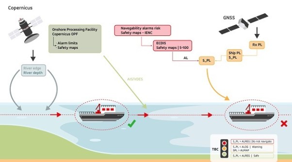
The goal of the 37-month-long project is to improve navigation for autonomous vessels along Europe’s inland waterways by using European Union space systems such as the European Global Navigation Satellite System (E-GNSS) and Copernicus.
In addition to improving navigation in inland waterways, the project is expected to help develop new applications for autonomous vessels, as well as contribute to the European Union’s goal of transforming transportation systems to make them more sustainable and less polluting.
Inland waterway transportation in Europe is undergoing several changes as a result of new and emerging technologies, which are making these processes increasingly safe, digitalised and sustainable.
While there is currently no autonomous vessel traffic in inland waterways, the industry is getting ready to incorporate it in the near future, and is therefore exploring the challenges that could arise in various scenarios.
In this regard, the solution proposed in AVIS will increase the accuracy and reliability of forecasts and enhance positioning for vessels, in order to optimise their routes and make them safer.
Further goals of the AVIS project include:
- Defining requirements for autonomous vessels and for operating such vessels in Europe inland waterways.
- Developing a prototype for onboard equipment.
- Providing proof of concept for the AVIS solution through several pilot tests on European inland waterways to prove its feasibility and added value.
- Developing new regulations establishing the minimum requirements to guarantee safe navigation as a contribution to the European Committee for Drawing Up Standards in the Field of Inland Navigation.