The 2015 Australasian Hydrographic Symposium & Trade Exhibition will be held 3-7 November in Cairns in tropical north Queensland. The symposium’s theme, “Harnessing the Blue Economy Through Hydrography In the Asia-Pacific Region” focuses on role of hydrography to the world’s and regional economies, and the opportunities this poses the profession of hydrographic surveying and businesses related to the maritime industry. It aims to assist many of the developing states within the Australasian region in identifying issues affecting their economies and development.
The symposium will bring together speakers from various maritime fields including specialist hydrographic streams, maritime transport, oceanography, offshore exploration, environmental science, maritime heritage, defence, tourism, coastal development, ports and harbours, and government. In doing so, attendees will gain insight into the effects of global warming, maritime trade and the threats and opportunities that are arising within the hydrographical industry.
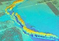
Cairns has been selected as the venue due to its relavance to the symposiusm’s aims, including its very close proximity to the Great Barrier Reef and one of the major shipping routes within Australian waters. Over 300 delegates from both the Australasian region and overseas are expected to attend.
Name: The Australasian Hydrographic Symposium & Trade Exhibition 2015
Time: Various
Date: 3-7 November 2015
Venue: Cairns Convention Centre
Address: Sheridan St & Wharf St, Cairns QLD 4870
Cost: day delegates $350, students $500, members $1,200 (members early bird $1,000), non-members $1,400 (non-members early bird $1,200)
Event Website: http://bit.ly/1QZmYPo