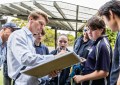
Astron geospatial manager Sam Atkinson and Geoimage’s technical manager Sylvia Michael.
Astron Environmental Services and Geoimage have announced that they have entered into an agreement to exchange their capabilities in satellite imagery, geospatial solutions, environmental monitoring and management.
The arrangement allows Astron to work closely with its clients to source highly accurate and consistent imagery to support vegetation health monitoring, vegetation mapping and rehabilitation monitoring which it undertakes for a range of clients across Western Australia.
Geoimage was founded in 1988 and was acquired by Jensen Bowers Group in February 2015, combining the unique capabilities and innovative technologies of both organisations.
Astron has been providing Western Australia with a broad range of environmental services for over 30 years and integrating remote sensing approaches into traditional services since 2012.
“In the last two years Astron has purchased over 1,700 square kilometres of satellite imagery from Geoimage for use on client projects,” said Astron geospatial manager Sam Atkinson. “This has predominantly been 4 and 8 band multispectral data from the very high resolution Worldview-2 satellite, and in October 2014 Astron was one of the first companies in Australia to take delivery of data from the new Worldview-3 satellite,”
“Low cost satellite imagery and the density of information that our Geospatial team can extract from it is giving our clients more certainty and significantly lower overall cost in comparison to traditional methods,” said Atkinson.
“This partnership agreement further enables Astron to leverage Geoimage’s technical knowledge and processing capabilities to improve the outcomes we deliver to our clients.”