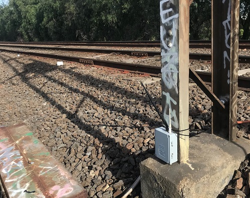
Leica Geosystems’ WiSenMeshWAN Omni tilt meters (small white boxes) attached to ends of railway sleepers.
Wireless tilt meters are revolutionising survey monitoring work on Australia’s railway projects.
PARTNER FEATURE
When it comes to surveying, sometimes doing things the traditional way is the right way, and at other times new technology comes along that changes the game completely. One such technology is affordable, mini, portable tilt meters that remove the need for time-consuming total station/prism set-ups. They’re finding applications in many aspects of civil engineering, including in the railway sector, as we will describe below.
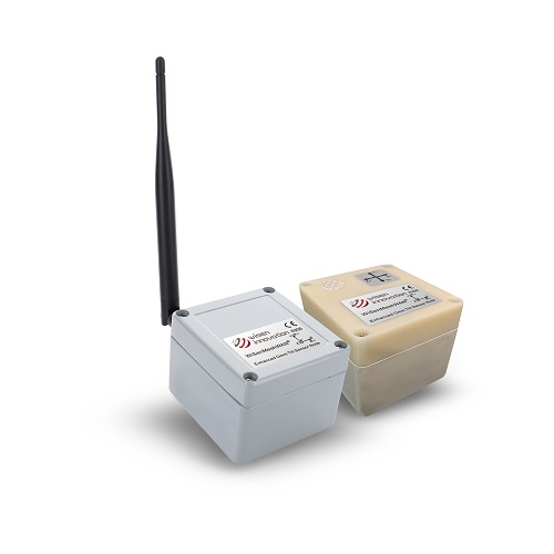
The new generation of smart tilt meters is exemplified by the Leica Geosystems WiSen range — distributed in Australia by CR Kennedy — which includes the tilt meters themselves plus smart wireless gateways and data systems that connect the meters and process the data.
At the core of the system is the WiSenMeshWAN Omni Tilt & Tilt R Node internally powered sensor, which enables measurement of tilt from the horizontal plane, with a full tilt range (360° any axis) and very high accuracy (±0.002°) and resolution (±0.0001°). These omni-axis sensors can be installed in any orientation and automatically detect precise movement in the horizontal plane.
The nodes also include an integrated temperature sensor and wireless mesh radio transmitter that uses a small, built-in external antenna. The battery lifespan is up to 10 years at half-hourly readings.
WiSenMeshWAN nodes communicate via bespoke encrypted mesh radio technology and can be located up to 1.5 kilometres from each other or the SmartGateway central data hub. The sensors mesh together and automatically form a network that relays data from one to another (up to 10 sub-mesh levels of data hop) and back to the SmartGateway.
The SmartGateway is a 4G connection gateway and edge computing data hub for WiSenMeshWAN nodes. It contains the back-up data logging functions, radio mesh control systems and external 4G communication to the WiSen cloud-based monitoring software or locally hosted system. The WiSen cloud-based monitoring software manages scheduling of the connected sensors, reads and displays data, sets alert level, manages complex rail calculations, email alerts, and manages automatic reporting. In case of communication failure, data is buffered locally until the communication is restored. The SmartGateway has an internal battery which can last up to 8 months, but it can also be powered externally.
WiSenMeshWAN Omni Tilt & Tilt R Node features
-
- WiSenMeshWAN Node
- Omni-axis tilt 360° range
- ±0.0001° resolution
- Intelligent node/repeater
- Battery life up to 10 years
- 1 second to 1 hour variable readings
- End user configurable
- Rugged housing
- IP66
- Gravity Orientation Sensor
WiSenMeshWAN SmartGateway Features
-
- Onboard SD memory card
- 4G Modem
- Digital interface
- Integrated radio
- Battery life up to
- 8 months
- External DC solutions
- Central WiSenMeshWAN data hub
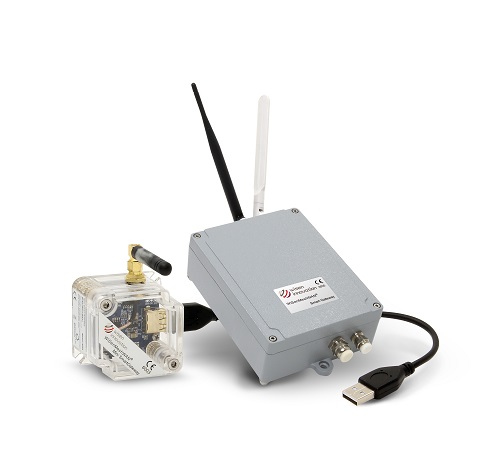
There’s also a SmartGateway Mini option, which is a USB SmartGateway for the sensor nodes. It manages the scheduling of the connected sensors and reads data from the node and transmits it to the local data server over USB connection. Locally stored data can be pushed to the WiSen cloud or imported immediately to the monitoring software. The SmartGateway Mini is directly powered from the USB connection.
The beauty of the tilt meters is that they are completely wireless and can be quickly placed in position via a simple baseplate or adhesive, and then they act as a set-and-forget system that does its job by periodically relaying its data via the wireless mesh.
Efficiency on the rails
Track Link Surveys is an engineering survey company based in Melbourne that specialises in heavy rail and light rail. The company does work for all the major Tier 1 contractors, involving construction works, detailed surveys and a lot of monitoring surveys.
Rail operators are understandably anxious about any kind of work that needs to be done with the ‘angle of repose’ close to the train line. Any boring or digging within the angle of repose or under the tracks requires a monitoring plan. And when brand new tracks are involved, that monitoring needs to run for a certain period of time to make sure that nothing fails within the construction methodology.
There are three different ways you can monitor tracks. A traditional solution is to set some targets on the track and have a surveyor go out and survey them every day or every second day — whenever the client wants it. Then there is the automated total station system, which is essentially the same but without having the surveyor on site all the time — it runs automatically. And then there is the tilt sensor option, where sensors are placed on the end of sleepers and continuously record movement of the tracks at a set interval.

A close up view of Leica Geosystems’ WiSenMeshWAN Omni tilt meters attached to railway sleepers.
“We were one of the first to implement tilt sensors in Melbourne. CR Kennedy got us involved early on, because of our work in rail projects,” said Michael Cadd, Track Link Survey’s survey manager.
Cadd says the tilt meters are particularly useful for specific applications.
“It’s like all surveying — there are particular applications for each instrument or each solution. It depends on what the client wants and what works are happening,” he said. “One of the main reasons why they can be used in this specific rail space is because they are small and they’re wireless. And that’s what you need within the rail space, because you’re usually not allowed to put anything large on the tracks. It’s a very controlled space.”
Cadd is also impressed by the software. “The interface from the measurements in the field into the office is very easy to use, and you can produce a pretty easily understandable graph for the client with a few clicks of a button,” he said. “It’s extremely user-friendly, especially the WiSen system itself — the user interface is quite good. There is some really good functionality in the system, whereby you can get quite detailed information if you want to.”
Cadd says that once they are set up and on site, the tilt meters are a significant cost saving compared to the other methodologies. One reason is that, unlike prisms, they don’t have to be put on both sides of the rail; you only need one per sleeper.
A Leica Geosystems WiSenMeshWAN SmartGateway.
And the system also frees up the company’s surveyors for other tasks. “We’ve found it’s better to utilise our skilled surveyors in different aspects of survey work, such as building the tracks, and not ‘waste a resource’ by just doing monitoring surveys that can be done via an automated solution,” said Cadd.
How about accuracy? Track Link Surveys set up a test system in a controlled environment to compare the performance of the tilt meters against a traditional automated total station, and the measurements came in within a millimetre or so. “So yeah, we’re very confident in the data we get from them. If you know how to use them, they give you the right results,” said Cadd.
“From my point of view, they are a really good solution. They’re part of a surveyor’s kit, and one of the things we do as a company is try to invest in new technology,” he added. “It’s like when GPS came along — it became part of our kit for doing surveys. Tilt meters are now an essential part of our monitoring solution for clients. They are usually our first go-to solution.”
This article was first published in the Apr/May 2022 issue of Position magazine.
Stay up to date by getting stories like this delivered to your inbox.
Sign up to receive our free weekly Spatial Source newsletter.