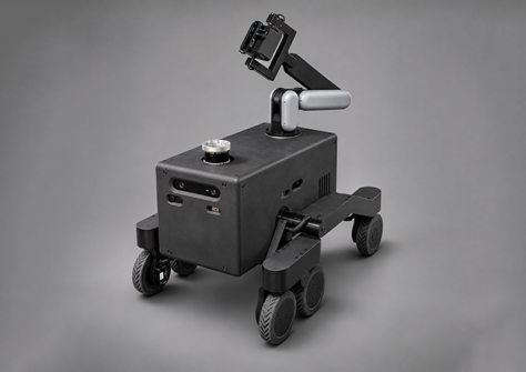
Hidonix says its Hido II rover is designed to accelerate spatial data acquisition, including in stairwells.
Hidonix Industries has announced the official launch of Hido II, a rover designed to accelerate spatial data acquisition.
First introduced as a prototype at CES 2026, Hido II is now being introduced through a limited deployment program for selected partners and venues across the USA.
Hido II is designed to make spatial mapping faster and more precise in complex environments, where data collection can require moving equipment across multiple floors, stairways and uneven terrain.
Developed entirely in-house, the rover combines advanced robotic mobility, automated navigation and proprietary acquisition technology to support geomagnetic mapping for ION, Hidonix’s indoor-outdoor navigation and spatial intelligence platform.
With a technician supervising on-site, Hido II follows defined survey routes, detects and avoids obstacles and navigates stairs while collecting geospatial data, reducing the need for continuous manual control.
Since CES 2026, Hidonix has introduced automated navigation capabilities, extended runtime and a fully functional modular robotic arm.
The company says that in comparative testing, Hido II reduced mapping time by 50% and achieved positioning error up to five times lower than manual acquisition using the ION App, demonstrating its potential to streamline the preparation of complex venues for indoor positioning and navigation.
“Since introducing Hido II at CES earlier this year, our team has focused on transforming a promising prototype into a practical solution for real-world spatial data acquisition,” said Achille de Pasquale, CEO of Hidonix.
“Its official launch represents an important milestone in our efforts to bring robotics and automation into spatial intelligence, making indoor mapping faster, more precise and less dependent on manual processes.”
Hido II mapping rover capabilities
Automated navigation: Follows defined survey routes under technician supervision, with real-time obstacle detection and dynamic path replanning.
Mobility: Proprietary rocker-bogie suspension enables the rover to navigate uneven terrain, climb conventional stairs, rotate in place and move laterally.
Extended operating runtime: Supports approximately five to eight hours of operation, depending on activity and operating conditions.
Modular robotic arm: Supports controlled, repeatable positioning of Hidonix’s acquisition module, helping to minimise magnetic interference and improve data consistency.
Advanced sensing: Combines a front-mounted 2K stereo camera with an Ouster LiDAR for depth reconstruction, obstacle awareness and 360-degree point-cloud acquisition.