A 39-square-kilometre aerial LiDAR scanning campaign has identified seven potential gold exploration targets in northern Queensland.
Gold mining company Clara Resources has announced the results of an aerial LiDAR survey of its Mareeba Gold Project site in Queensland’s Hodgkinson Basin.
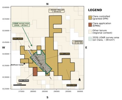
The survey covered the Kingsborough Fault corridor, which had been the focus of an extensive Western Mining Corporation (WMC) drilling campaign between 1986 and 1989, plus adjoining ground.
The Mareeba Gold Project sits inside a historically significant gold-producing region, with the broader Hodgkinson goldfield having produced approximately 300,000 ounces of gold from multiple deposits.
The Kingsborough Fault — the principal structural target within Mareeba — had not previously been subject to modern, systematic exploration since WMC discontinued exploration.
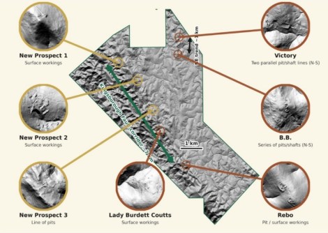
As a result of the new LiDAR work, existing targets have been further resolved and three new targets have been identified that are interpreted to represent additional historical workings on previously unrecorded ground.
What the Clara Resources aerial LiDAR scans found
The LiDAR program was flown in March using a crewed fixed-wing aircraft supported by surveyed GNSS ground control. The total acquired ground footprint was approximately 39 square kilometres.
Survey deliverables include a classified point cloud, a 1m digital terrain model, a 1m digital surface model and high-resolution orthophotography.
Average point density across the survey area was approximately 8 points per square metre, which is sufficient to resolve sub-metre ground features beneath vegetation cover across the survey footprint.
The initial step in interpreting the LiDAR dataset was to overlay the survey data on the locations of four documented historical gold workings within the Mareeba Gold Project tenements: Victory, B.B., Lady Burdett Coutts and Rebo.
Each working was examined at the 1m hillshade scale to characterise its surface expression in the LiDAR dataset.
Depth information cited (but not yet independently verified) for these workings was sourced from the Queensland GeoResGlobe database1, which records reported depths of historical mineral occurrences.
Systematic gold exploration using modern techniques
According to the company, the consistency of the LiDAR results at the four documented historical workings sites indicates that the dataset is capable of resolving anthropogenic, historical mining-related surface features at this scale.
This calibration provided the basis for systematic identification of similar features across the remainder of the survey area, examination of which for surface anomalies displaying similar topographic characteristics resulted in three additional targets being identified that are interpreted to represent possible historical workings on previously unrecorded ground.
“This LiDAR survey sharpens our view of the Kingsborough Fault corridor within our Mareeba Gold Project. While historical drilling confirmed the presence of gold mineralisation, the corridor has not been systematically assessed using modern exploration techniques,” said Clara Resource’s Executive Director, Duncan Gordon.
“Identifying and mapping historical workings at scale — including previously unrecorded ones — gives us a more complete picture of the structural framework controlling mineralisation, and greater confidence in prioritising targets and planning our exploration program.
“The upcoming ground-based work will be critical in validating these interpretations and supporting the design of a targeted drill campaign along this corridor.”