


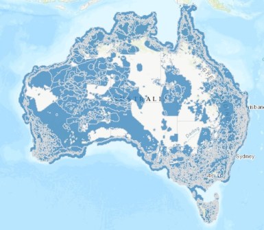
The most detailed GIS datasets and maps of Australian protected species distributions have been released.
The federal Department of Climate Change, Energy, the Environment and Water’s (DCCEEW) Environment Information Australia branch (EIA) has prepared the data using high-quality sources to show where land- and marine-based protected species of fauna and flora are likely to be present.
The data also therefore shows where those fauna and flora have not yet been found.
According to the Department, the resource will:
- Enable developers to plan projects to account for and avoid sensitive areas; and
- Enable conservationists to target locations that are most at need for protection or restoration.
The Department says that EIA continually improves its data and modelling approaches, with updated models using finer, high-resolution data that provide a more thorough and more accurate insight into species and habitats at regional and national levels.
Publicly available data
Fauna and flora that are formally considered to be of national environmental significance are protected under the Environment Protection and Biodiversity Conservation Act 1999 (EPBC Act).
The protected species datasets have been modelled with regard to species occurrence records, environmental data (e.g. soil, climate and vegetation), and expert knowledge about species traits and habit requirements.
All of the data is publicly available at 100-metre resolution and will be enhanced over time. Data will also be updated if species lists change if the EPBC Act is modified, or as new knowledge becomes available.
The data for some particularly sensitive species’ locations has been generalised in some instances.
A user guide and a technical manual are available for download.
The latest GIS datasets themselves are available online:


