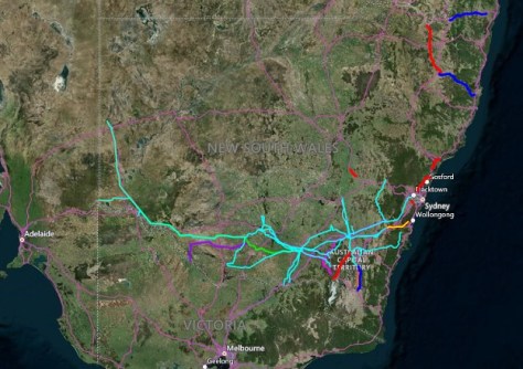
Electricity network operator, Transgrid, has begun its statewide scan of powerlines and easements.
The annual aerial patrol program is intended to help safeguard the company’s extensive high-voltage transmission network in the lead up to the coming summer’s fire season.
The seven month-long endeavour, begun in February and running through to September, will not only assess the condition of powerlines and towers, but also will look for vegetation encroachments along the network’s easements.
“Bushfire risk is something we plan for well before summer arrives,” said Jason Krstanoski, the company’s Executive General Manager of Network.
“Our aerial patrol program helps us identify potential issues early, prioritise maintenance and reduce risk across the network — helping keep our people, landowners, communities and the electricity system safe.”
Reducing bushfire risk
The 2026 program involves crews conducting visual inspections from low-flying helicopters, plus the capture of high-resolution imagery for engineering review.
In addition, fixed-wing aircraft are being used to conduct a 3D LiDAR scan to spot any vegetation growing too close to the Transgrid transmission lines.
A continually updated interactive map of planned works is available online.
“Preventative maintenance is one of the most effective ways to reduce bushfire risk,” said Krstanoski.
“These inspections help ensure we’re doing the right work, in the right locations, at the right time — well before extreme conditions occur.”
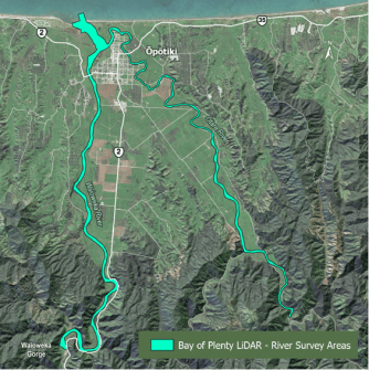
River reviews
Meanwhile, across the ditch, the Bay of Plenty Regional Council has been conducting aerial bathymetric LiDAR scanning of several rivers in the Eastern Bay of Plenty.
The work has involved flying a LiDAR-equipped helicopter at low altitude along river channels and margins.
Ground surveys are also being carried out.
“This work helps us better understand how our rivers function, which is critical for understanding river behaviour, maintaining assets, and protecting people and the environment,” said Niroy Sumeran, the Council’s Engineering Team Leader for the project.