

With the current bushfire season still with us for a while yet, councils across NSW are using new maps to keep track of bushfire-prone land.
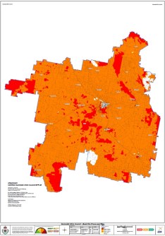
In Gunnedah in the state’s mid-north, the shire council is using an updated Bush Fire Prone Land (BFPL) map certified by the NSW Rural Fire Service (RFS).
The updated BFPL map replaces the previous map, which had been certified 23 years ago in 2003.
The NSW BFPL dataset has been prepared in accordance with the Guide for Bush Fire Prone Land Mapping (BFPL Mapping Guide) and certified by the Commissioner of the NSW RFS under Section 10.3 of the Environmental Planning and Assessment Act 1979.
Council’s Manager Building and Strategic Projects Blake O’Mullane said the update reflects statewide requirements.
“The NSW RFS Guide for Bush Fire Prone Land Mapping indicates that every Council in NSW is required by legislation to map bushfire-prone land,” he said.
“The newly certified map takes effect immediately and will be used for all development control and strategic planning purposes.”
The BFPL map was certified by the Deputy Commissioner of the RFS on 9 January 2026 and the map is available on Council’s website, however, interactive online mapping on RFS’s website may not be available for another week, and the NSW Planning Portal Spatial Viewer for one to three weeks.
Since the certification of the Shire’s previous BFPL map, the NSW Government has introduced Vegetation Category 3, as updated in the Planning for Bush Fire Protection 2019 guide.
This category represents grasslands and is now reflected in updated mapping across the Shire.
Mr O’Mullane said the changes do not prevent compliant development from occurring.
“The changes don’t affect landowners unless they lodge a Development Application (DA) and/or Complying Development Certificate (CDC) Application for their property,” he said.
“Where land is mapped as bush fire-prone, a site-specific bush fire risk assessment needs to be carried out as part of the DA and/or CDC process.”


