

NASA has selected two new Earth sciences satellites for development, including the Earth Dynamics Geodetic Explorer (EDGE) mission.
EDGE is being described as the world’s first global, swath-imaging LiDAR satellite, capable of simultaneously monitoring land, ice and coastal regions.
Both EDGE and the other mission — STRIVE, the Stratosphere Troposphere Response using Infrared Vertically-resolved light Explorer — will undergo further development before being subjected to a progress and funding review in 2027. The launches, if they go ahead, will take place no earlier than 2030.
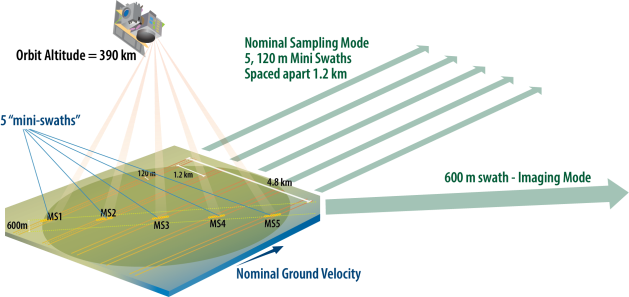
Led by Helen Amanda Fricker at the University of California San Diego, EDGE is designed to provide global coverage by obtaining continuous data in five, 120-metre-wide swaths at higher resolution that any previous satellite altimeter.
“I am so delighted to lead the EDGE mission, bringing together a cross-disciplinary team of scientists and engineers with a shared goal of developing a next-generation instrument to measure the vital signs of our planet in our most critical regions,” said Fricker, who also serves as the Director of the Scripps Polar Center.
“EDGE mini-swaths will provide unmatched global coverage, exceeding all prior laser altimeter missions to bring key features into clear focus, and extend LiDAR records for decadal change detection.”
The mission will build upon the experience gained with NASA’s ICESat-2 (Ice, Cloud, and land Elevation Satellite 2) and GEDI (Global Ecosystem Dynamics Investigation), the former being a free-flying satellite and the latter being an instrument deployed on the International Space Station.
Aussie involvement
Dr Alex Fraser of the Australian Antarctic Program Partnership (AAPP) at the University of Tasmania, is a collaborator in the EDGE project.
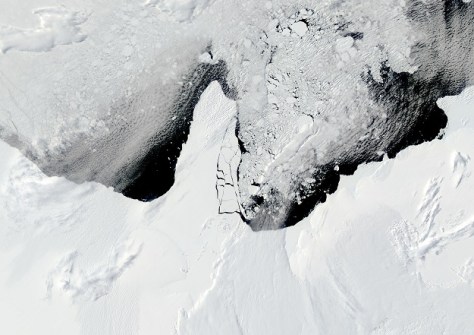
“My work involves tracking how sea-ice coverage around Antarctica is changing over time under global heating, and this satellite will revolutionise that research,” he said, adding that EDGE will be used to “measure the height of Earth’s dynamic surface in incredible detail, from deepening cracks in Antarctic glaciers to the height of Amazon rainforest,” he said.
“The EDGE satellite will be capable of measuring vertical differences with an accuracy of less than three centimetres from an orbit 390 kilometres above the Earth.”

The satellite will be equipped with 40 LiDAR beams compared to the six aboard ICESat-2.
In addition to Dr Fraser, there are other Aussie connections to the mission. The principal investigator, Fricker, obtained a PhD in glaciology from the then Institute of Antarctic and Southern Ocean Studies at the University of Tasmania in 1998.
And Dr Petra Heil, an AAPP affiliate who formerly worked at the the Australian Antarctic Division and is now with the British Antarctic Survey, is a collaborator.
Fire and ice
“EDGE will provide detailed portraits of ice sheets, especially the rapidly changing glaciers and ice shelves near the coasts,” said team member Ben Smith, a glaciologist with the University of Washington.
“We will be making maps of crevasses and rifts in the places where short-term changes are really driving the evolution of the cryosphere.”
Smith was part of the ICESat-2 team, so he’s more aware than most of the value that EDGE will bring, should it win final approval in 2027.
“One of the strengths of this laser altimeter mission is that we know how to use it and how to stitch it together with a multi-decadal record of change — connecting the data products directly to measurements that began in 2003.”
But it won’t be just the ice-covered regions of the planet that the EDGE mission will be used to monitor — it will also be employed for biodiversity monitoring, fire risk assessment and carbon storage accounting.
“EDGE delivers first-of-its-kind capabilities that enable consistent, high-precision monitoring of 3D forest habitat from the tropics to the boreal,” said team member Chris Hakkenberg from UCLA.
“These same measurements will inform next-generation wildfire management tools that reduce risk to communities while improving public health and national security.”


