

California now has statewide LIDAR-derived vegetation cover data mapped at 10m and 30m resolutions, with 1m available for selected areas.
This is the state’s first complete collection of consistent data on forest and vegetation cover.
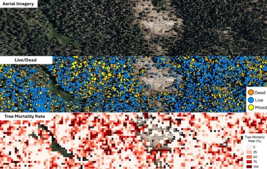
The data provides information on where trees and shrubs are located, how tall and dense they are, where ‘ladder fuels’ might carry fire into the canopy, and how much carbon is stored in the vegetation.
The data release was announced by the California Natural Resources Agency (CNRA), in partnership with the California Air Resources Board (CARB), NASA Ames Research Center, and the Wildfire and Forest Resilience Task Force.
It comes thanks to the Wildfire, Ecosystem Resilience, and Risk Assessment Initiative (WERK), which has processed more than 40.5 million hectares of LiDAR data across the state.
The effort has involved the collaboration of multiple agencies, tribes, researchers, land managers, and community partners, each of whom are now able to incorporate the data into their own models and planning processes.
According to NASA Ames, the data is “tailored to California’s shrubland, grassland, and forest ecosystems, as well as urban forests, orchards, croplands, wetlands and deserts”.
The WERK effort will produce five high-resolution data products, being:
- Change detection and attribution;
- Land cover classification and mapping of the six most common land cover types;
- Individual tree monitoring;
- Built-structure mapping; and
- WERK-wide analysis and assessment of the first four products.
The datasets are hosted in partnership with the Wildfire Science & Technology Commons at the San Diego Supercomputer Center, supported by the National Science Foundation.
The 1m data will become available statewide in early 2026.


