

Inertial systems based on quantum sensors, and navigation by the Earth’s magnetic field, are under investigation.
Facing increasing challenges to the dependability of the GNSS due to jamming and spoofing, the world’s militaries are actively canvassing alternative options for positioning and navigation.
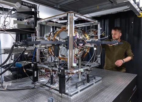
For example, in the frigid Arctic, Imperial College London and the Royal Navy have been putting a quantum-enhanced inertial sensor system to the test.
The sensor uses the wave-like quantum behaviour of cold atoms to gauge acceleration and rotation, independent of signals from external sources.
Such systems exhibit high accuracy and stability over time.
The challenge is to take them from a climate-controlled laboratory and put them into real world applications, where they must contend with weather, vibration and many other potential disturbances.
In the real world
“In the lab our quantum sensors perform extremely well, which is why we’re so excited about their potential for inertial navigation,” said Dr Joseph Cotter, lead scientist for the project, who works across two of Imperial’s research departments (Physics and Materials).
“The Arctic field trial lets us test how these devices perform in unpredictable environments, and helps us work out what we still need to do to make them shock resistant, and able to withstand life at sea.”
First demonstrated in 2018 and then again aboard a small Royal Navy research ship in 2023, Imperial’s quantum sensors have also been trialled on the London Underground rail network.

“As Head of Futures in the Royal Navy’s Disruptive Capabilities and Technologies Office (DCTO), I am delighted that Dr Joseph Cotter’s team at Imperial College London was able to test its revised Quantum Inertial Navigation Sensing (INS) technology, onboard MV Anvil Point,” said Commander Matt Steele of the Royal Navy.
“This experiment builds on previous sea trials, using the RoRo fleet, which has enabled iterative development and performance improvements to the sensor.
“The DCTO looks forwards to continuing this long-term collaboration with Imperial College London to develop a GNSS-independent INS prototype and demonstrate quantum operational advantage for the Royal Navy.”
Magnetic navigation
Quantum sensors take advantage of the characteristics of the tiny atomic world. In the US, the Department of War (DoW) is looking for solutions that take advantage of a macro, planet-wide phenomenon — magnetism.
The DoW has issued a challenge to the commercial world to come with solutions for its proposed Geomagnetic Airborne Unmanned Survey System (GAUSS).
According to the DoW, GAUSS is a “multi-year, multi-phase initiative which will culminate in mature technology demonstrations that provide magnetic map data to enable operational magnetic navigation of trans-oceanic distances”.
And that means airborne magnetic mapping systems. The DoW has asked vendors to submit proposals for two kinds of systems: one that would map the Earth’s magnetic field from an altitude of 30,000 feet and able to collect 1,000,000 km of line data per year , and the other from 2,000 feet and able to collect 400,000 km of line data.
Among other things, those proposals should:
- Support the rapid integration of off-the-shelf magnetometers;
- Ensure accurate navigation for data collection; and
- Ensure collection over a variety of over-water domains.
Making it work
“Compelling solutions should develop data collection concepts that… can be rapidly scaled to accelerate magnetic data collection efforts, enable cost-effective data collections, and ensure that sensors can be installed in a magnetically clean location,” the DoW says.
It also says it is “interested in validating techniques that provide corrections for diurnal magnetic field variations over water at distances over 1,000 miles [1,600 kilometres] from the nearest magnetic base station”.
“Solutions can include, but are not limited to, space-weather modelling and estimation, the deployment of loitering diurnal monitoring assets, or other novel techniques. Expertise in magnetic data processing is expected to include traditional levelling techniques…”
Only time will tell whether these and other GNSS alternatives will be able to provide the accuracy and reliability needed by modern militaries. But one thing’s for sure: in an increasingly uncertain world, the vulnerability of the GNSS must be addressed.


