

While many global road maps exist, few include detailed surface information or keep pace with rapid infrastructure change.
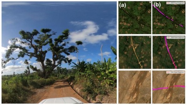
A new Heidelberg Institute for Geoinformation Technology (HeiGIT) dataset closes this gap by combining 3- to 4-metre resolution PlanetScope imagery (2020–24) with deep-learning models to analyse 9.2 million kilometres of major transport routes connecting cities and rural regions.
The result is a high-accuracy global classification (89.2%), outperforming widely used open datasets by over 20 percentage points.
A central component of the dataset is the Humanitarian Passability Score — an index that combines surface type and width to estimate accessibility under varying conditions.
This metric supports better routing for logistics, infrastructure management and emergency planning.
“With this dataset, humanitarian actors can identify which routes are likely to remain accessible under extreme weather or seasonal disruptions,” says Prof. Alexander Zipf, HeiGIT Scientific Director.
“It provides a missing piece for navigation in regions where reliable road information is scarce.”
Beyond routing, the dataset also links improvements in road quality to human development.
HeiGIT’s analysis reveals pronounced disparities: Europe and North America’s roads are more than 96% paved, while Sub-Saharan Africa averages only 63%, with the infrastructure deficit concentrated primarily in rural areas.
Regions with a higher share of paved roads and a faster pace of new paving since 2020 tend to achieve higher Human Development Index levels, highlighting infrastructure as a dynamic measure of socioeconomic progress.
Such data can support governments, development organisations, and researchers in assessing where strategic investment in road infrastructure would strengthen connectivity and resilience.
“Unlike traditional indicators such as nighttime lights, road networks reveal development at the local-level, showing how change unfolds on the ground.” says research lead Dr. Sukanya Randhawa.
“By linking satellite imagery to patterns of economic development, we turn infrastructure change into a measurable signal of both progress and vulnerability.”
The dataset’s multi-temporal design captures shifts in road conditions as new infrastructure is built or existing roads deteriorate. This enables applications from global monitoring to local decision-making.
By transforming road network from a static inventory into a dynamic indicator of change, the dataset provides a globally consistent foundation for informed routing and accessibility planning, while supporting the monitoring of progress toward the UN Sustainable Development Goals (SDGs).
The dataset is openly available via the Humanitarian Data Exchange — the open data platform operated by the United Nations Office for the Coordination of Humanitarian Affairs (OCHA) — and will be updated annually.


