

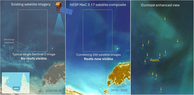
More than 1,000 previously unmapped reefs in northern Australian waters have been identified as part of a Marine and Coastal Hub project, using improved satellite imaging and remote sensing methods.
In those remote, sediment-rich waters, the reefs had remained largely hidden, missing from official maps and mostly invisible to decision-makers.
Thus, despite providing habitats for a wide range of marine life, they have been overlooked when it comes to conservation and development planning.
The project team, led by the Australian Institute of Marine Science and the University of Queensland (UQ), set out to solve the problem by using a comprehensive catalogue of satellite imagery, machine learning and existing field data to reveal reef systems previously missed by older techniques.
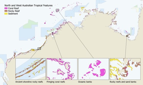
The team put in 700 hours of manual mapping and classifying reef boundaries to create the first comprehensive view of coral reefs boundaries across northern Australia… including more than 4,000 coral reefs and 3,000 rocky reefs.
The team also upgraded the shallow reef habitat mapping first developed as part of the Allen Coral Atlas.
Improved satellite imagery, substantially more training data, and constraining the automated machine learning with the manual reef boundary mapping markedly increased delineation of habitats.
According to the team, “We found that existing coastline datasets such as the Geodata Coast 100K 2004 and the Australian Hydrographic Office (AHO) Australian land and coastline dataset did not meet our needs”.
“The scale of the Geodata Coast 100K 2004 was too coarse to represent small islands and the positional error of the Australian Hydrographic Office (AHO) Australian land and coastline dataset was too high (typically 80 m) for our application as the errors would have introduced significant errors in the shape of small fringing reefs.
“The Digital Earth Australia Coastline (GA) dataset was sufficiently accurate and detailed however the format of the data was unsuitable for our application as the coast was expressed as disconnected line features between rivers, rather than a closed polygon of the land areas.”
The new maps give planners, Traditional Owners and managers a much clearer view of reef and habitat locations.
“Having this level of detail means these important reef habitats can now be considered in environmental planning … It helps protect biodiversity and avoid unintended impacts,” said Dr Eric Lawrey, the Project leader.
While the core study area was from the Houtman Abrolhos island chain in Western Australia to western Cape York in Queensland, the team also rolled out the new technique across the Great Barrier Reef to see whether additional reefs could be detected.
The timing was ideal, as a separate UQ project was remapping the outer reefs of the Great Barrier Reef. They adopted the new imagery, helping to identify hundreds of additional reefs and to remove false reefs.
This revised dataset is now under review by the Great Barrier Reef Marine Park Authority.
Other outcomes from the project include:
- A national high-resolution geospatial database of the Australian coastline at a scale of 1:50,000;
- A georeferenced media library containing over 480 videos and 20 articles showcasing reef habitats across the north;
- A video tutorial on georeferencing YouTube videos for virtual fieldwork;
- A new raster dataset on tidal statistics across the Australian marine region; and
- Tropical Australia Satellite Composite Imagery datasets showing the best cloud-free and clear-water imagery available for reef mapping.
The final datasets will be openly available through public data portals, including the eAtlas and the Australian Ocean Data Network.


