

Courtesy Blackshark.ai
Maxar Technologies has announced a strategic investment in Blackshark.ai, a provider of AI-powered geospatial analytics services.
The investment will enable Maxar to bring additional 3D capabilities to broader markets for more customers and open up a new revenue stream from Blackshark.
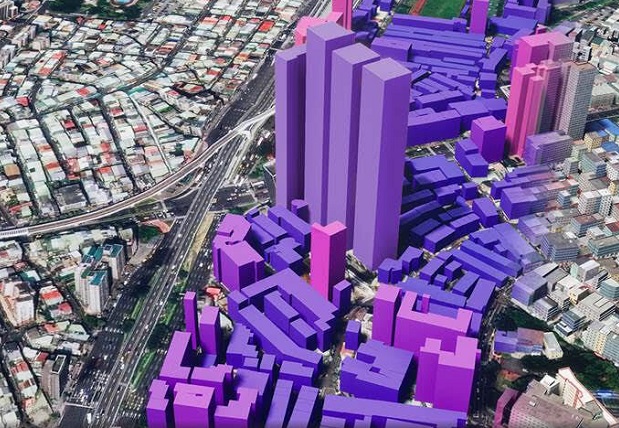
The Blackshark.ai platform processes petabytes of satellite imagery in hours, detecting and segmenting objects, roads, vegetation and other infrastructure on the Earth’s surface without human intervention. This information is used to create a comprehensive 3D digital model of the world.
Blackshark.ai will leverage Maxar’s global cloudless satellite imagery basemap, Vivid, to create a highly performant and photo-realistic 3D map for enterprise and government customers in industries such as gaming, metaverse, simulation and mixed reality environments.
For example, this type of offering would enable flight simulator customers to access immersive 3D digital experiences with low latency and global scale… useful for customers who may not need the global accuracy of Maxar’s full Precision3D suite.
“We’re excited to partner with Blackshark.ai to extend our geospatial analytics offering and bring a AAA video-game quality 3D digital twin of our planet to market,” said Dan Nord, Maxar Senior Vice President and General Manager of Enterprise Earth Intelligence.
“By integrating our industry leading Vivid basemap with Blackshark algorithms, we expand our customer set by complementing our high accuracy Precision3D portfolio with this lighter weight, visually stunning option.”
“The combination of our offerings positions us to create a digital twin of our planet as real as it gets,” added Michael Putz, Founder and CEO of blackshark.ai.
“We cannot wait to see our customers and partners using this to disrupt many industries.”
Stay up to date by getting stories like this delivered to your inbox.
Sign up to receive our free weekly Spatial Source newsletter.


