A multi-institution team has been awarded $650,000 in ARC funding to purchase LiDAR units for use in mapping and studying Australia’s coastal environments.
The multidisciplinary team intends to use the devices as drone-based, bathymetric scanners to map the coastline in unprecedented detail, especially in hard-to-reach areas.
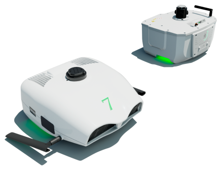
The LiDARs in question are the TDOT3 Green sensor, which has a 60,000 Hz pulse rate, 30 lines/second scan rate, 90° field of view, and four return signal collection capacity; and the TDOT7 Green sensor, which has a 160,000 Hz pulse rate, 80 lines/second scan rate, 120° field of view, and six return signal collection capacity. They’re also equipped with cameras.
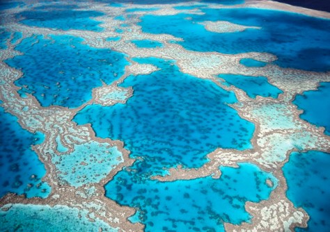
The green laser technology is especially suitable for penetrating coastal waters, so that underwater shelves and reefs can be mapped.
The ARC Linkage, Infrastructure, Equipment and Facilities scheme funds equipment and facilities that can be used by all the members within the successful consortia.
In this case, data generated from the CoastElBathy facility will underpin development of models urgently needed to project shoreline change due to storms, climate variability and sea-level rise.
According to the team’s funding submission, “A key component of CoastElBathy will include infrastructure to support development of high-resolution three-dimensional models of coastal and river shallow-water environments that can be fully integrated with adjacent elevation models and bathymetric surveys of the seafloor and river channels, which is identified as a top priority for coastal and river geoscience, engineering research and management.”
The purchase of the LiDAR units is also being supported by Environmental Futures, a research institute at the University of Wollongong that focuses on environmental changes across Australia, particularly in coastal environments.
Associate Professor Sarah Hamylton from the University of Wollongong (UOW), is looking forward to using the system to study coral reefs.
“I’m particularly interested in taking it up to one of my study sites up on the Great Barrier Reef, a place called Low Isles, that’s got this big coral reef system… and so looking at mapping the reef platform and the different marine communities that live on it, like corals and algae,” she said.
Hamylton says she wants to look at “the intersections between coastal biology and geology. We can use the marine LiDAR to map in great detail the things that are creating the sand that creates the islands… [and] look at longer-term stability of low-lying islands.”
The CoastElBathy facility investigators are: Professor Kerrylee Rogers; Associate Professor Sarah Hamylton; Professor Barbara Bollard; Professor Neil Saintilan; Professor Kirstie Fryirs; Associate Professor Hannah Power; Dr Christopher Owers; Dr Michael Kinsela; Associate Professor Mitchell Harley; Dr Thomas Oliver; Professor Ana Vila Concejo; Associate Professor Eleanor Bruce; Dr Thomas Doyle; Mr Patrick Dwyer; Dr Timothy Rawling.
In related news, another multi-institution team led by Flinders University has secured $450,000 under the ARC Linkage scheme for mapping deeper waters.
The Submerged Environments Survey and Sampling Suite will employ two marine geophysical sonar sensors and one marine geotechnical coring platform.
The sonar sensors are the R2Sonic Multibeam, which is optimised for high-resolution 3D sonar seabed mapping, and the Innomar Compact Subbottom Profiler to map the shape and depth of shallow sediments below the seabed.
According to the team, these sensors — combined with the coring platform — will provide an integrated, affordable capacity for Australian universities to expand their research into deeper waters and deeper underwater sediments in both marine and freshwater environments.
The team’s investigators across all the institutions involved are: Dr John McCarthy; Associate Professor Jonathan Tyler; Dr Alexander Francke; Professor Jonathan Benjamin; Dr Chelsea Wiseman; Professor Ian Moffat; Professor Sean Ulm; Professor Julien Louys; Associate Professor John Tibby; Dr Mark de Bruyn; Associate Professor Graziela Miot da Silva; Mr Mathieu Bestille.