

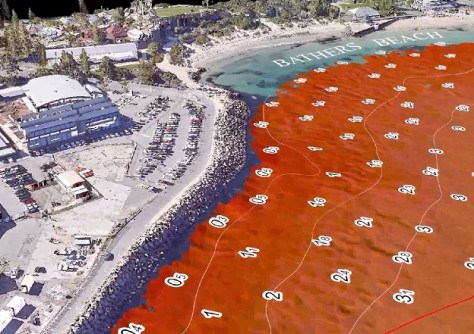
The seabed off Fremantle’s Bathers Beach has been mapped in high-resolution 3D to ensure the safety of competitors and officials taking part in the inaugural Perth Sail Grand Prix event.
Experts from WA’s Department of Transport and Major Infrastructure (DTMI) have combined traditional hydrographic sonar data showing water depths and drone-captured, high-resolution LiDAR data for above-water features.
DTMI undertook the mapping project as part of the formal approval process for SailGP, which included assessing safety risks above and below the waterline prior to its endorsement of the event.

“The result was a very detailed 3D computer model of the racecourse and surrounding seabed showing known areas of concern including the location of the enduring underwater piles of the original Fremantle Long Jetty extending west from Bathers Beach and also the depth of water around the breakwaters at South Mole and Challenger Boat Harbour,” said DTMI Maritime Coastal Information Director, Jenny Bothma.
“The model is an invaluable resource for organisers to use to identify hazards and eliminate safety risks.”
The mapping also provided more detailed information about the location of the known shipwrecks off Bathers Beach. DTMI has shared that data with the WA Museum.
“The new, very detailed data not only gives organisers greater confidence to safely manage this large international event, it also provides valuable additional information for DTMI’s nautical chart for the area — boosting ongoing safe navigation by commercial and recreational craft,” said Bothma.
The Bathers Beach data and other bathymetry data are available on DTMI’s WA Bathymetry Portal.


