[This Q&A is part of an article exclusively published in the February/March Issue of Position magazine.]
Recognising International Woman’s Day with one of the industry’s most inspiring professionals.
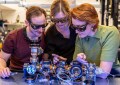
After winning a streak of coveted prizes for her innovation in Remotely Piloted Aircraft (RPA), Dr Catherine Ball is not so interested in winning more awards but rather in her new projects that span the globe and all levels of government and business. The UK-born but Aussie-at-heart innovator holds a PhD in spatial ecology and in 2015 excelled to new heights, becoming Director of Applied Innovation at Elemental Strategy as well as a Digital Transformation Taskforce Member at Municipal Association of Victoria. Ahead of her keynote at Locate Conference in April, she shared with Position her exciting views of the future.
Dr Ball’s Recent Awards:
- National Telstra Business Woman of the Year 2015, Corporate and Private Award
- BOSS Magazine Young Executive of the Year 2015
- Queensland Business Woman of the Year 2015, Corporate and Private Category
- Innovator of Influence, 2015 Innovation Week
- Courier Mail Q Magazine: Queensland 50 Best and Brightest, 2015
AW: Congratulations on a massive 2015. What was it that saw you take out so many impressive awards?
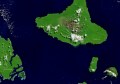
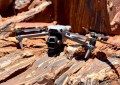
CB: Effectively I was the project manager on a number of world firsts in terms of applying remotely piloted aircraft (RPA) and thought leadership to ecological monitoring and engineering projects. Some of those involved flying long-range beyond-line-of¬site remotely piloted aircraft off the West Australian coast to look at various offshore islands, and along highways in remote Queensland. Some project outcomes from across Australia included imagery from remote environments without having humans walking over it; anything really that you would capture when flying over an offshore island or along a remote highway with around 2cm pixel resolution photogrammetry, for example, erosion or vegetation assessments. No one had actually applied these types of RPAs to commercial purposes regarding monitoring on an engineering project, and that allowed us to evaluate how effective the ecological and engineering decisions could be when using these types of data.
AW: How will you possibly top it off in 2016? Can you tell me about any upcoming projects?
CB: No, not yet, but watch this space. I’ve already got a number of projects that are mind-blowingly huge and going to be pretty cool. But I’m more interested in new projects than receiving awards. My current work involves everything from applying new technology—including RPAs—and other ways of collecting spatial data, including from new satellites that are going up at the moment. And then applying that to our current monitoring programs: everything from bushfire monitoring through to coral reefs, water quality, turtle activity, agriculture, pest species, safety, security, policing and science, plus the geo-ethics of RPA based data collection. I’m still advising lots of foreign projects as well. We’re looking at projects in Antarctica, New Zealand, the Arctic, South America and parts of Europe, but my passion still lies with Australian projects and people.
I’ve gone independent; been unleashed from any restrictions on me in terms of commercial capacity working for a large consultancy. I’m bridging that gap between the scientists, the business people and the legislators, and it’s an interesting place to be. Everyone speaks slightly different languages to each other, so sometimes we need translators or bridge builders…
The rest of Dr Ball’s Interview will be exclusively published in the February/March Issue of Position magazine. To subscribe to Position magazine, please click here.
Dr Catherine Ball will be appearing at Locate Conference 2016 to deliver a keynote address, 12-14 April 2016 at the Melbourne Convention and Exhibition Centre.
Visit http://www.locateconference.com for further information.