Topcon Positioning Systems and Fixposition have entered a collaboration agreement.
The companies say the deal is intended to result in technology integration in future product offerings.
It’s just the latest example of companies working in different spheres within the geospatial sector, joining forces to produce synergistic effects.
Fixposition has been integrating Topcon RTK corrections into its Vision-RTK sensors since 2023, when the companies announced an agreement providing Fixposition customers with access to the Topnet Live RTK corrections service network.
“Working with companies such as Fixposition — specialists in Visual RTK (real-time kinematic) and visual-aided positioning — helps create added value for our customers,” said Ron Oberlander, head of the Topcon Geomatics Platform.
Oberlander points out that users are increasingly having to work in environments where satellite signal reception can be challenging, such as urban jungles.
“Fixposition offers technology that augments satellite positioning, beneficial for users even while working inside structures and in indoor-outdoor transitions, without disrupting workflows by combining RTK GNSS with artificial intelligence to ensure position accuracy,” said Oberlander.
“We see this AI-enabled technology as an innovative integration with our next-generation GNSS solutions.”
Reality capture
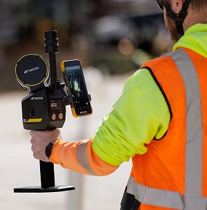
Meanwhile, for its reality capture portfolio, Topcon has introduced the CR-S1, a handheld scanning system that combines LiDAR, panoramic cameras, visual SLAM cameras, and a GNSS antenna in a single device.
Topcon says the CR-S1 takes advantage of the company’s Collage mass-data software ecosystem, and provides higher point‑cloud density, extended scanning range and upgraded panoramic imaging compared to the CR-S2.
Software support includes MAGNET Flow for Android and iOS devices, MAGNET Bridge for SLAM data desktop processing.
The CR-S1 also can be connected to the aforementioned Topnet Live RTK GNSS corrections service.