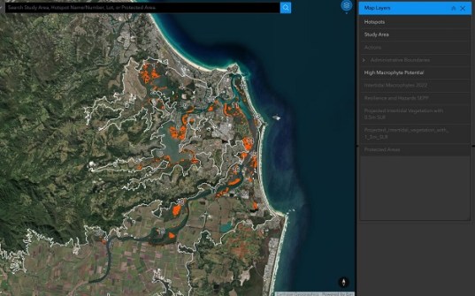
A new desktop mapping tool will assist land managers assess and protect estuarine areas along the NSW coastline.
The interactive ArcGIS tool — developed by the Intertidal Marine Vegetation Strategies (IMVS) project team within the NSW Marine Estate Management Authority — brings together multiple datasets and resources to help land managers work out practical ways of tackling problems in their local areas.
Currently, the tool contains detailed data on the Tweed River estuary in northern NSW. Information on the Richmond River estuary and estuaries near Kiama will soon be added.
The IMVS project, funded by the Marine Estate Management Strategy, aims to develop strategies to restore and protect saltmarsh and mangroves within estuaries.
Those ecosystems are on the frontline of sea level rise (SLR), and as such play an important role in climate change resilience.
For instance, if an area of mangrove is cleared, not only is stored carbon released, but remobilised sediments can diminish water quality.
According to the Authority, some of the activities and factors that pose the highest risk to saltmarsh and mangroves along the NSW coast are:
- Stock grazing on riparian and marine vegetation;
- Extraction, artificial barriers to riverine and estuarine flow, urban drainage and impervious surfaces;
- Estuary entrance modifications;
- Sea level rise; and
- Clearing of riparian and adjacent habitats, including wetland drainage.
The full range of risk factors and activities, divided by region and assigned a score of high, moderate or minimal, can be found in the following table.

This video outlines how to use the tool: