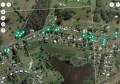
Simulation results for an unmanned drone flying over downtown Los Angeles showing the true trajectory (red line), with GPS navigation only (yellow line), and GPS aided with cellular signals (blue line). Image: ASPIN Laboratory at UC Riverside
In what may prove to either be a fundamental technological revolution, or a just a lofty academic idea, researchers have proposed a method to overcome the shortfalls of satellite-based GNSS navigation using the vast array of electromagnetic signals that have been in common use for decades.
From everyday citizens to surveying and spatial professionals, the world has become increasingly dependent upon satellite-based GNSS systems, popularly known as GPS. However, the use of these technologies indoors or in urban canyons is fraught with issues. With the advent of driverless cars and autonomous RPAS (or drones), the need for reliable navigation in any environment is rapidly growing.
The solution to indoor mapping, therefore, has become a holy grail in recent years as many innovators seek to overcome the problem with new hardware and signals.
New research from the University of California, however, throws out that idea by suggesting that the existing array of environmental signals such as mobile phone signals, Wi-Fi and even radio may hold the key.
To get stories like this delivered to your mailbox every week, subscribe to our weekly newsletter.
A team of researchers at the University of California, Riverside (UCR) claim to have developed a “highly reliable and accurate” navigation system that exploits these existing signals and can be used as a standalone alternative to GNSS.

A schematic showing how Zak Kassas and his team are using existing communications signals to complement satellite-based navigation systems like GPS for the control of driverless cars and unmanned aerial vehicles. Image: ASPIN Laboratory at UC Riverside
At the very least, the system is able to complement current GPS-based systems to enable more reliable, consistent, and apparently tamper-proof navigation. The technology, they claim, could also be used to develop navigation systems that meet the stringent requirements of fully autonomous vehicles, such as driverless cars and unmanned drones.
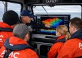
Led by Zak Kassas, assistant professor of electrical and computer engineering in UCR’s Bourns College of Engineering, the team presented its research at the 2016 Institute of Navigation Global Navigation Satellite System Conference (ION GNSS+), in Portland in September.
The two studies, “Signals of Opportunity Aided Inertial Navigation” and “Performance Characterization of Positioning in LTE Systems,” both went on to win best paper presentation awards.
“By adding more and more sensors, researchers are throwing ‘everything but the kitchen sink’ to prepare autonomous vehicle navigation systems for the inevitable scenario that GPS signals become unavailable,” lead researcher Zak Kassas said. “We took a different approach, which is to exploit signals that are already out there in the environment.”
Kassas’ team in the UCR Autonomous Systems Perception, Intelligence, and Navigation (ASPIN) Laboratory aim instead to develop autonomous vehicles that could tap into the hundreds of signals around us at any point in time, like cellular, radio, television, Wi-Fi, and other satellite signals.
In the research presented at the ION GNSS+ Conference, Kassas’ team showcased ongoing research that exploits these existing communications signals, described as “signals of opportunity (SOP).”
The system can be used by itself, or what hey believe is more likely, to supplement GNSS signals and data from Inertial Navigation Systems (INS).
“Autonomous vehicles will inevitably result in a socio-cultural revolution.” Kassas said. “My team is addressing the challenges associated with realizing practical, cost-effective, and trustworthy autonomous vehicles.”
“Our overarching goal is to get these vehicles to operate with no human-in-the loop for prolonged periods of time, performing missions such as search, rescue, surveillance, mapping, farming, firefighting, package delivery, and transportation.”