

In our regular Spatial Snippets feature, we bring you a round-up of all the bits and pieces of geospatial news that didn’t make it into our normal daily coverage.
Do you have a Spatial Snippet to share with our 8,000-strong newsletter list? Please send us an email.
Tasmania’s Surveyor General, Michael Guidici, has announced he will retire on 19 December after 12 years in the role. He will be succeeded in the role by Matthew Reid. We wish Michael all the best in his retirement.
Esper Satellite Imagery is on a hiring spree, looking to fill several positions across the fields of geospatial, geology and embedded systems engineering. The job ad on LinkedIn implies the company is seeking only one person, but Esper tells us they’re actually hoping to fill two or more positions from the one batch of applicants. The company is an Aussie start-up success story, having already launched its own satellites, won awards and received substantial prize money.
On the subject of jobs, here are few geospatial roles up for grabs that we’ve spotted lately:
- Spatial Analyst (Spatial Mapping Unit), Queensland Department of State Development, Infrastructure and Planning
- Senior Remote Sensing Officer, Queensland Department of Local Government, Water and Volunteers
- GIS Systems Architect, City of Launceston
If research is more your thing, the University of Western Australia has a PhD scholarship going for someone interested in using remote sensing and machine learning to tackle the problem of floating marine debris.
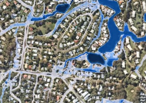
Sticking with the aquatic theme, and the Sunshine Coast Council has updated its publicly available flood mapping products to take account of development in parts of its LGA, as well as flood mitigation works and insights gained from the experience of living through ex-Tropical Cyclone Alfred, which hit the area in March this year.
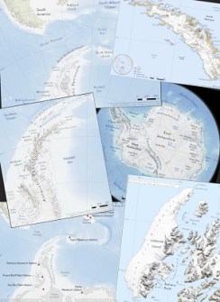
From tropical waters to polar, the British Antarctic Survey has released a new online catalogue that provides access to a large collection of high-quality polar maps, many of which were previously unavailable to the public.
In oceanic news, GEBCO has released a beta test version of its data download application. The new version enables users to select defined regions to download data and explore multi-resolution data in selected regions in the waters surrounding Australia, New Zealand and the Hawaiian islands. Data are available in NetCDF, GeoTIFF, and ASCII formats. The new version will replace the current version early next year.
The launch of the next two Galileo First Generation satellites will take place on 17 December. Galileo Lauch 14 (carrying SAT 33 and SAT 34) will be the first to employ the new Ariane 6 rocket. Galileo currently has 31 satellites on orbit; the planned constellation complement was completed in 2024, and the first of the early satellites was decommissioned in April this year. Following December’s launch, there will still be four more First Generation Galileo’s to place in orbit, after which the Second Generation will start to take over.
The Japan Aerospace Exploration Agency is aiming to launch Michibiki No.5, or Quasi-Zenith Satellite System 5 (QZS-5) aboard an H3 rocket on 7 December. QZS-5 will join the four other QZSS satellites that have been in orbit since 2018. Currently, three satellites are visible at all times from locations within the Asia-Oceania region.
Looking at events coming up, don’t forget that Alistair Hart from Mangoesmapping will present a webinar on 3 December to brief the industry on the capabilities of the new Emlid Reach RX2, RS4 and RS4 Pro units.
If you’re concerned about the weaknesses of Australia’s (and the world’s) positioning, navigation and timing (PNT) systems, then you won’t want to miss tomorrow’s FrontierSI webinar. Eldar Rubinov will share insights from FrontierSI’s Armouring the Clock project, which has been looking at Australia’s PNT vulnerabilities. He’ll also outline emerging policy, governance and capability pathways to reduce reliance on single points of failure for PNT systems.
Survey and Spatial New Zealand has some webinars coming up that will be of interest to surveyors:
- Underground Asset Location, 3 December, 1 CPD point
- Are your GNSS measured distances correct?, 8 December, 1 CPD point
- Introduction to Simultaneous Localisation and Mapping (SLAM), 18 December, 1 CPD point
West Tech Fest, billed as Australia’s longest-running technology and innovation festival, returns from 8 to 12 December. One of the event’s top speakers will be Lars Rasmussen, well-known as one of the co-founders of the mapping platform that led to Google Maps.
Still in the west, and the Geographical Society of Western Australia’s Young Geographer of the Year Competition 2026 has been launched. Now in its ninth year, the 2026 competition will focus on the theme of sustainability, in keeping with the UN’s declaration of next year as the International Year of Volunteers for Sustainable Development. If you know of a young person who might be interested, let them know.
Finally, in a similar vein, the Australian Geography Competition for school students in years 7 to 12, will be held again next year. The competition will run from 28 April to 13 May, with registrations opening in January. The winners will have the opportunity to take part in the iGeo International Geography Olympiad, which next year will take place in Istanbul. (Australia will host the event in Melbourne in 2028.) Again, if you have or know of school students who might be interested, please bring it to their attention.
Make sure you don’t miss out any geospatial news from across Australia and around the world — subscribe to our free Spatial Source newsletter, sent out every Wednesday and Friday morning.


