

Our weekly round-up of all the geospatial news that didn’t make it into our normal daily coverage.
If you have a Spatial Snippet to share with our readers , please send us an email.
We’ll start with some more job vacancies we’ve spotted on our travels. This section of Spatial Snippets is proving popular with readers, so we hope you’re finding it interesting too… and maybe of direct value to you one day if you’re ever looking for a new job.
Hunter Water in NSW is on the lookout for a GIS Analyst to be responsible for maintaining high-quality spatial data, supporting field and project data capture, and contributing to the development and automation of contemporary geospatial solutions that enable informed decision-making across the business. Applications close 30 March.
Sunwater in Brisbane has an opening for a Spatial Analyst to maintain and enhance enterprise GIS datasets, provide spatial data governance and assurance for major projects, contribute to the development and implementation of GIS data governance frameworks, and support integration of GIS with digital engineering initiatives. Applications close 30 March.
The City of Moreton Bay in Queensland is on the hunt for a Spatial Analyst to join its Strategic Planning and Place Making Department. The successful applicant will develop, manage, and maintain spatial datasets, produce high‑quality maps and spatial outputs, undertake spatial analysis, and develop and maintain web maps and interactive spatial applications. Applications close 30 March.
Also in Queensland, the Department of Environment, Tourism, Science and Innovation has an opening for a Senior Catchment Modeller to join the Paddock to Reef Catchment Modelling team and help protect the Great Barrier Reef. In terms of qualifications, GIS experience is a plus. Applications close 27 March.
In Wollongong, NSW, the NSW National Parks and Wildlife Service needs a Project Officer Threatened Species to work on a team contributing to the conservation of the natural environment, flora, fauna and Aboriginal heritage. You need good spatial skills, and demonstrated competency in data analysis and use of information systems, such as a working knowledge of GIS, databases and statistical applications. Applications close 1 April.
And across the ditch, Auckland Council has a vacancy for a Healthy Waters Specialist with a working knowledge of GIS tools, who can turn complex data into clear insights to support planning and operations. Applications close 27 March.
FrontierSI has appointed Chris Roach as its Project & Delivery Lead. Roach has a strong background in environmental technology across government and private industry in both Australia and Canada, with broad expertise across natural resource management, water, geoscience, Earth observation, biodiversity, health, fire, utilities and mining.
Do you know any Year 10 students in Victoria who are mad about science? Deakin University is offering a week-long, hands-on Laboratory Science Work Experience program for students. Although the topic area is mainly molecular biology and cell science, the course will involve GPS/GIS mapping and ecological surveys. Full details here.
GeoCart’2026, New Zealand’s 12th National Cartographic Conference, will convene from 26 to 28 August at the Te Aro campus of Victoria University of Wellington. The event aims to bring together a wide cross-section of professionals, researchers, and enthusiasts engaged in cartography, map curatorship and research, geo-visualisation, and GIS science.
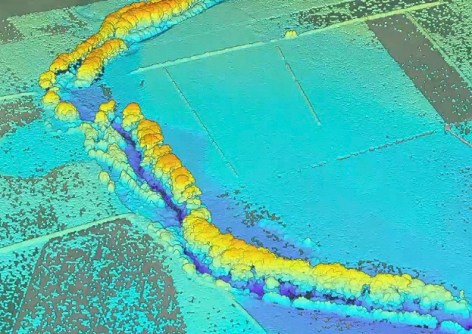
Here’s something nifty for New Zealand farmers. The Good Farm Mapping Experience gives farmers free access to high-resolution mapping that shows how water, nutrients and sediment move across their land. The work has been developed in partnership with Collaborations, an environmental and water science consultancy specialising in spatial analysis and catchment-scale modelling, which has taken nationally available LiDAR data and applied peer-reviewed science to transform it into practical outputs that land managers can use.
Make sure you don’t miss out any geospatial news from across Australia and around the world — subscribe to our free Spatial Source newsletter, sent out every Wednesday and Friday morning.


