In our regular Spatial Snippets feature, we bring you a round-up of all the bits and pieces of geospatial news that didn’t make it into our normal daily coverage.
Do you have a Spatial Snippet to share with our 8,000-strong newsletter list? Please send us an email.
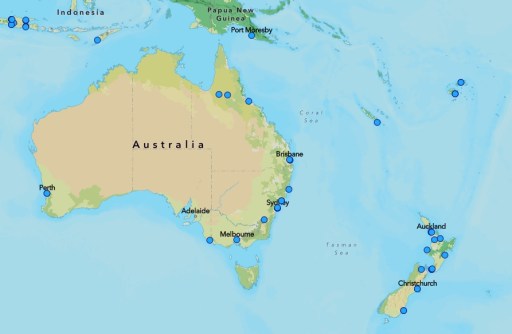
Today is GIS Day today, celebrated every year on the third Wednesday in November and with this year marking the 26th anniversary of the day’s founding.
GIS Day is billed as being a day dedicated to educating and inspiring students, colleagues and the wider community, showing them how GIS contributes to the betterment of society.
The event began in 1999 when Esri’s Jack Dangermond, along with Dr Roger Tomlinson and students, celebrated the first GIS Day at Murch Elementary School in Washington, DC.
The map at the top of the page shows the locations of GIS Day events being held today across the region.
On the subject of GIS, the Women in GIS (WiGIS) organisation is holding its second annual WiGIS Map Contest. WiGIS is inviting members to submit traditional or creative maps they’ve made and show off their cartographic skills. The deadline is 31 January 2026 (US time).
If you’re a geospatial or IT professional looking for a job or a change of scenery, there’s a position going at Vicmap that might interest you. The Imagery Stream Lead, Data Acquisition and Contracts (Vicmap) works within the Vicmap Spatial Services team in the Data and Digital Division, overseeing the acquisition and management of imagery and 3D spatial data to support state and local government needs. Applications close Monday, 24 November 2025 at 11.59pm.
If you’re in the research field, there are several options on offer at the University of Tasmania at the moment. First up are four postdoc positions:
- Postdoctoral Fellow in Antarctic Satellite Geodesy (4 years)
- Postdoctoral Fellow in Environmental Spatio-Temporal Statistics (4 years)
- Postdoctoral Fellow in Glacial Isostatic Adjustment Modelling (4 years)
- Postdoctoral Fellow in Antarctic Ice Sheet Reconstruction (3.5 years)
There are also three new, funded PhD projects. Successful applicants will join a team of about 15 researchers working on tracking and predicting the future of the East Antarctic Ice Sheet. The project is supported with travel and professional development funds through a recent ARC Laureate Fellowship award.
The three projects are:
- Beyond GPS: Tracking Antarctica’s changing shape using multiple Global Navigation Satellite Systems (GNSS)
- Resolving glacier and solid Earth interactions in the Antarctic Peninsula with machine learning and numerical modelling
- Data-Informed reconstructions of East Antarctic surface mass balance and firn densification
It is expected that more PhD positions will be offered in 2026 for 2027 starts. Informal enquiries can be directed to Matt King, Professor of Polar Geodesy, via Matt.King@utas.edu.au.
This year’s Tasmanian Surveying & Geospatial Conference will be held this Friday at the C3 Convention Centre, South Hobart. Check out the program here.
Consulting Surveyors NSW (CSN) is holding a Land Registry Services (LRS) briefing webinar on 25 November, to cover the Surveying and Spatial Information Regulation 2024 following the transition period, which will come into effect on 1 January 2026.
The webinar will also cover the digital plans mandate timeline and upcoming enhancements in the LRS Connect portal. You don’t have to be a CSN member to register.
If you’re into GNSS receivers, Mangoesmapping will hold a webinar on 3 December to brief the industry on the capabilities of the new Emlid Reach RX2, RS4 and RS4 Pro units. The hour-long event will see Alistair Hart take participants through all the features of these new devices.
Don’t forget that the PNT2026 conference is coming up in Sydney in February. The event will bring together hundreds of experts from across Australia and around the world to discuss and debate the latest developments in the sphere of positioning, navigation and timing.
Make sure you don’t miss out any geospatial news from across Australia and around the world — subscribe to our free Spatial Source newsletter, sent out every Wednesday and Friday morning.