Airbus Defence and Space imagery dated 20 September 2015 shows ongoing development of the artificial island created at Fiery Cross Reef in the South China Sea.
China has completed the runway on Fiery Cross Reef in the South China Sea and is moving closer to making it operational, based on analysis of the latest satellite imagery. The completion of the runway could allow China to accelerate construction on the new island and to start patrols over the disputed islands. Airbus Defence and Space imagery taken on 20 September shows helipads and bearings painted on the 3,125 m-long runway on the newly created island.
The completion of the runway, which previous imagery suggests only occurred in recent weeks, will allow China to accelerate construction of infrastructure and potentially start air patrols over the Spratly Islands, which are claimed and occupied by a number of countries.
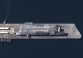
Chinese construction workers continue to build multiple structures on the island, complete the seawall in the harbour and create concrete road networks. They also appear to have dumped topsoil along the side of the runway; this may be the first attempts to grow food on the island or just be the start of landscaping designed to prevent erosion.
The Fiery Cross Reef area is administered by China, but has also been claimed by the Philippines, Taiwan and Vietnam. It sits in South China sea in close proximity to the heavily disputed Spratly Islands and surrounding land formations.