20% cloud from February 2009 to September 2010
RapidEye is celebrating its collection of more than 1 billion km² of image data in a little over a year. Substantial recent coverage is now available for Australia, China, India, Africa and New Zealand; with captures for select parts of PNG and SE Asia now underway.
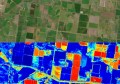
RapidEye is the only geospatial solutions provider to own and operate a constellation of five identical Earth Observation satellites. The spectral and spatial qualities of RapidEye sensors are attracting a group of users working on a range of applications including mining, rail, oil and gas, agriculture and environmental monitoring.The constellation of five satellites is capable of downloading over 4 million km² of high resolution, multi-spectral imagery per day. The unique combination of large area coverage, high spatial resolution and the possibility of daily revisits provide a valuable and cost effective information source.


AAM can assist agencies seeking data anywhere in the world. Many early adopters are benefiting from the cost effective regional overview available from RapidEye data whilst also utilising GeoEye-1 data over small areas of interest that require greater spatial resolution.
Contact us for more info on RapidEye imagery for your project area or sign up for receipt of AAM’s quarterly Satellite News Broadcasts at info@aamgroup.com .
Gail Kelly, Nils Matthews or Haila Hamdan
Phone: +61 7 3620 3138
Email: imagery@aamgroup.com
Web: www.aamgroup.com/rapideye