

What has been described as Australia’s most detailed regional climate projections are now mapped and available on SEED, the central repository for Sharing and Enabling Environmental Data in NSW.
Known as the NSW and Australian Regional Climate Modelling (NARCliM) project, it is helping decision-makers understand and prepare for the effects of climate change.
In particular, NARCliM projections are being used for managing risks such as bushfires, floods, droughts and heatwaves.
As extreme weather events become more common, NARCliM projections provide strategies to reduce their impact on infrastructure, businesses, health, industries, and communities.
One example cited is the need to know when temperatures are likely to rise above 40°C, as this is when railway lines might begin to buckle or warp, and train speeds therefore need to be reduced to prevent derailments.
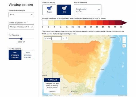
SEED’s interactive map enables users to combine NARCliM data with other datasets, such as those for bushfire-prone land or species sightings, enabling decisions to be made to help protect infrastructure, ecosystems and communities.
An updated version of the SEED map was released in July this year.
According to Matthew Riley, Director, Climate and Atmospheric Science in the NSW Department of Climate Change, Energy, the Environment and Water (DCCEEW), NARCliM is “the finest-resolution climate modelling ever made available for states and territories in Australia”.
“NARCliM date will allow us to plan for those future extreme weather events,” he said.
“We want to ensure that there is a consistent approach to interpreting climate change information. Councils are likely to be required to develop disaster adaptation plans,” added Sarah Penny Joyce, Executive Officer, Sydney Coastal Councils Group.
“Plans will look at various hazards including sea level rise, urban heat, bushfire, and the NARCliM data will get a strong evidence base to develop those plans.”


