
New advanced sensors are making barometric levelling valuable for obtaining elevation data where GNSS data are unavailable.
By Gabriel Scarmana
Barometric altimeters, once primarily linked with aviation, parachuting and mountaineering, have now expanded into a wide range of applications due to the increased availability and affordability of advanced atmospheric pressure sensors.
These altimeters are now integrated into various electronic devices alongside Global Navigation Satellite Systems (GNSS), enabling the recording of vertical profiles along with latitude and longitude data. Consequently, barometric altimeters are embedded in a vast array of consumer electronics, including smart phones, watches, fitness bands, bicycle computers, GNSS-enabled handheld devices, and vehicle tracking systems.
In drone systems and aviation modelling, barometric altimeters are extensively used, with barometry often serving as a primary method for altitude measurement. Drones, in particular, use multiple altitude-measuring systems and switch between them as needed (e.g., radio, GNSS, infrared or laser altimeters). The barometer in a drone can measure both relative and absolute altitude, and provide readings in mean sea level (MSL) and above ground level (AGL) units, depending on the application.

This highlights the potential to further reassess the role of barometric altimeters in the geospatial industry, especially in large-scale topographic surveys and remote area mapping where traditional levelling methods are impractical. Barometric altimeters offer a cost-effective solution for determining elevation differences across extensive terrains, facilitating the creation of digital elevation models (DEMs) and aiding in the planning of infrastructure projects.
Moreover, barometric altimeters have revived interest in barometric levelling, a once forgotten surveying method for determining height differences between points on the Earth’s surface. Though this technique was commonly referenced in surveying textbooks, it fell out of favour as newer levelling technologies emerged. However, advancements in precise barometric sensors (e.g. MEMS sensors) and portable weather stations have significantly improved the accuracy and practicality of barometric levelling, making it a viable and straightforward levelling method.
This approach is particularly advantageous in environments where traditional levelling techniques face challenges, such as urban canyons, dense forests, tunnels or indoor navigation systems, where other altimetry methods may struggle. Once considered suitable only for reconnaissance or exploratory surveys due to perceived accuracy limitations, barometric levelling now challenges those assumptions with its enhanced precision and ease of use.
Under stable weather conditions, barometric levelling can be more reliable and accurate than a navigational GPS/GNSS receiver for measuring relative elevations between multiple points. Some handheld GPS/GNSS receivers incorporate built-in barometric altimeters and algorithms to fuse GPS/GNSS and atmospheric pressure data. This integration ensures that users can obtain more accurate and reliable elevation data, even in the absence of optimal satellite signals.
This article offers a concise and informative overview of the principles, instruments, methodology and applications of this overlooked levelling technique, highlighting its significance and practical use through a real data capture example. More in-depth theoretical explanations have been intentionally omitted but are available in specialised literature on barometric altimetry.
How does barometric levelling work?
As in barometric altimetry, barometric levelling operates on the principle that atmospheric pressure decreases with altitude. The barometric formula, which relates pressure to height, is the foundation of this method. By measuring atmospheric pressure at different points and applying this formula, it is possible to determine the height difference between those points. In other words, it is based on the basic standard that the pressure caused by the weight of the column of air above the observer decreases (or increases) as the observer goes higher (or lower) in elevation.
As with any levelling technique, the accuracy of barometric levelling is influenced by several factors, including temperature, humidity, the survey procedure, the skill and experience of the survey team, and the vertical and horizontal distances between measuring stations. Additionally, optimal results with this technique are achieved when the weather is stable and climatic conditions remain consistent, which in general are also common requirements for current levelling methods.
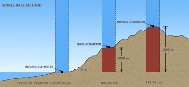
There are two primary methods for conducting barometric levelling surveys. The first is the single-base method, which involves using one base station for reference. One barometric altimeter remains at a base station, the elevation of which is known, while the other altimeter (the roving altimeter) is taken to other points or measuring stations where the elevation is to be determined. The difference in simultaneous reading corrected for temperature and pressure changes will give the desired elevation.
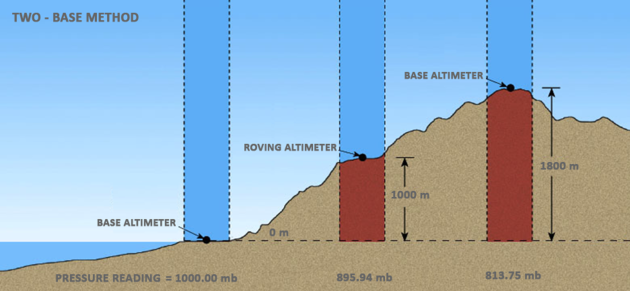
The second method, referred to as the two-base method is, considered the standard for accuracy. At a suitable low point within the area being surveyed, one base station is established while a second base station is positioned at a much higher elevation. One barometric altimeter is employed at each base and simultaneous readings are taken and recorded at predefined time intervals at the measuring stations across the area of interest.
The literature on barometric levelling also describes the leapfrog technique as a variation of the single-base method. In this approach, both instruments are initially read together at the base station. The rover then moves to the first measuring station, where readings synchronised with the base station are taken. Afterwards, the rover moves to the next measuring station, while the base station instrument relocates to the previous rover station. This leapfrog procedure keeps the instruments close together, enhancing the accuracy of the assumption that air pressure variations are consistent across locations. By bringing the instruments together more frequently, atmospheric drift is better controlled. Two operators are usually required for this technique to work.
To enhance accuracy, it’s essential to measure air pressure and temperature simultaneously at both the base and measuring stations. Barometric levelling is most effective when measurements are conducted within a few kilometres of the base station, especially on days with stable barometric pressure, often seen with gentle winds and clear or overcast skies. The distance between the base and measuring stations can vary depending on the accuracy of the barometric instruments, local weather conditions and the precision needed for the survey.
Barometric levelling offers several advantages. First, it enables elevation measurement in areas where GNSS signals are obstructed, making it ideal for locations with limited satellite access. Second, data computations can be easily performed using common office software like Microsoft Excel, streamlining data processing and analysis. Third, it is effective in rugged or inaccessible terrains, minimising the need for extensive physical groundwork. Additionally, modern barometric altimeters and weather data loggers are lightweight, compact and cost-effective, and they can be integrated into other devices, enhancing their practicality for field operations.
Testing the hypothesis
A barometric levelling survey was conducted on 6 July 2023 at Pacific Pines, a suburb of the Gold Coast (central coordinates E 153.326238, S -27.936753). The survey took place on a sunny morning with mild winds (2-4 km/h) and temperatures ranging from 17°C to 20°C. Barometric observations were collected at 25 randomly selected stations, averaging 0.7 km apart within a 10-square-kilometre area. The base station had a nominal elevation of 46.97 m, while the 25 measuring stations varied in elevation from 2 m to 140 m, as determined by differential levelling with an accuracy of ±0.02 metres.
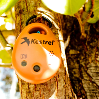
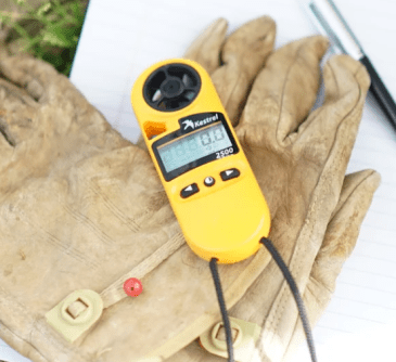
Known elevations at the 25 measuring stations in Pacific Pines were used as reference values to determine the actual difference at each station. Measurements were taken using a Kestrel DROP D3, a wireless temperature, humidity and pressure data logger, and the Kestrel 2500 weather meter (both made by the Nielsen-Kellerman Company, USA). The manufacturer specifies the accuracy (of the Kestrel 2500) as 1.5 hPa (at 2 sigma) or +/- 0.75 hPa, and it is able to capture and store barometric pressure, temperature, wind speed and humidity, and transfer data via Bluetooth for further processing. The Kestrel 2500 costs about US$170, while the Kestrel DROP D3 costs about US$150. The survey, completed in about 2.5 hours, involved one observer who took readings at each measuring station after allowing one or two minutes for the instrument to settle.
The Kestrel DROP D3 data logger was placed at the base station of known elevation and recorded the time, pressure, temperature and humidity at 10-minute intervals. Note that the instrument at this data logging frequency can store information for up to 40-plus days. Humidity was monitored to ensure stable atmospheric conditions but did not impact elevation calculations. Readings were taken from a 10 cm timber portable platform located on top of each measuring station. An interpolation method was used to synchronise readings between the base station and the measuring stations. The Kestrel 2500rover was used as the measuring device at each station. Transport between stations was carried out by driving a car.
Since the elevations of all stations were known, the absolute error for each measurement station was determined, resulting in a final root mean square error (RMSE) of ±0.49 m. Both instruments used in the survey were capable of measuring and storing air pressure with a precision of two decimal places, indicating that sub-metre accuracy in elevation estimates was theoretically attainable.
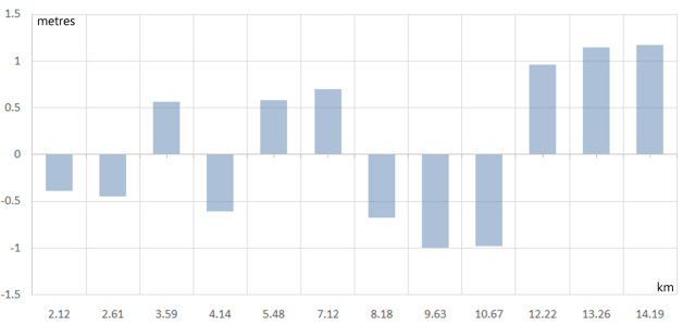
A similar, second test was carried out to determine the influence that distances from a given base station may have on the accuracy of the elevation of a measuring station. For this purpose, this exercise used an established permanent survey mark (elevation = 4.00 m) as the base station, and 12 permanent survey marks of known elevation as measuring stations. The distances of the known measuring stations to the base ranged between 2 km and 14 km whereas the elevations ranged between approximately 2.00 m and 140.00 m.
As expected, the computed elevations were much better at the first few measuring stations, which were nearest the base station, than the elevations determined at the remainder of the route. The errors tended to increase as the rover moved away from the base until, at measuring station 12, a maximum was reached. To give an idea of the accuracy achieved, the differences between the nominal elevations and the computed ones can be seen in the figure below. Readings of pressure, temperature, time and percentage of humidity (for monitoring purposes only) were carried out using the rover instrument and were synchronised with the base readings taken at intervals of 5 minutes. All subsequent computations followed the same process as per the previous example.
In this instance, measurements were taken in both forward and reverse directions, with the elevation results at each station averaged. The survey took approximately three hours to complete. For consistency, it was conducted under similar weather conditions as the previous exercise, on a sunny day with temperature variations of about 2.5°C from start to finish. As before, the task was carried out by a single operator.
Final views
One of the main challenges with barometric levelling is its sensitivity to changes in atmospheric conditions. Variations in weather patterns and local weather phenomena can introduce errors in the readings, leading to inaccuracies in the elevation measurements. To mitigate these issues, apart for ideal weather conditions, it is crucial to use portable barometric instruments (preferably of the same manufacturer) that can generate accurate simultaneous observations of pressure and temperature.
Using two synchronised barometric instruments helps simultaneously detect and correct sudden changes in atmospheric pressure, improving result reliability. This approach also reduces systematic errors that might affect each device differently. By synchronising the readings from both instruments, biases specific to each device are minimised, leading to better results.
Improving atmospheric correction models, developing more accurate barometric instruments, using more base stations with real-time data logging capabilities, and integrating data with other height measurement techniques is still recommended.

In summary, barometric levelling is valuable for obtaining elevation data where GPS/GNSS signals are unavailable. Advancing sensor technology and methods will enhance the precision and expand the use of barometric levelling in diverse geospatial fields, including areas related to environmental monitoring, geological surveying and infrastructure development.
One could argue that a similar survey could be conducted using portable GPS/GNSS receivers rather than using portable weather stations, as many smart phones and devices like Garmin© products are capable of also displaying latitude and longitude coordinates along with atmospheric data such as pressure and temperature. Although these products are valuable due to their high performance and advanced features, they are generally more expensive.
In contrast, using two instruments from the same manufacturer as described above, renowned for their reliable weather data logging capabilities at set intervals, ensures consistent measurement and availability of data collected by a single operator. Additionally, instruments specifically designed for portable weather stations, offer a more cost-effective solution. Their relatively lower cost combined with their suitability for accurate and dependable data collection makes them an appealing choice for barometric levelling surveys.
Gabriel Scarmana is an associate member of the academic staff at the University of Southern Queensland. He has maintained a longstanding, active interest in the fields of GIS and surveying throughout his career.