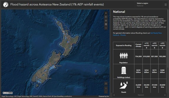
New research led by Earth Sciences New Zealand reveals that more than 750,000 New Zealanders live in locations exposed to flooding from one-in-100-year rainfall flooding events.
And this number could increase to more than 900,000 with a further 3 degrees of warming due to climate change.
Around NZ$235 billion worth of buildings across the country are exposed, which could rise to NZ$288 billion if there is 3 degrees of additional warming.
In addition, 26,800 km of the nation’s roads, 14,100 km of stormwater pipelines and 21% of national grid sites (e.g. substations) are also exposed to flooding under New Zealand’s current climate. This could rise to 30,800 km, 15,400 km and 29%, respectively, with 3 degrees of warming.
The findings come from the culmination of a five-year research programme looking at flood risk across Aotearoa New Zealand. The programme involved wide-ranging collaboration with other research organisations, universities, councils, central government agencies and industry.
A major output of the project is the country’s first nationally consistent flood risk hazard viewer. The researchers applied a consistent method for flood modelling from 1% annual exceedance probability (AEP) rainfall to create new maps for 256 flood plains around the country.
It is the first time that rainfall flood risk maps covering different regions of the country can be viewed in a single online tool. The mapping workflow was carried out for New Zealand’s current climate and then repeated for the three climate change scenarios (+1, +2 and +3 degrees of additional warming).
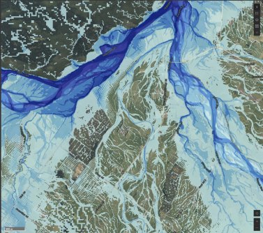
Earth Sciences NZ’s tool is complementary to localised maps already developed by many of New Zealand’s regional and unitary councils.
“In New Zealand, detailed local flood hazard maps are made available by local government agencies and provide essential information for local decision-making,” said Graeme Campbell, River Management Advisor for Te Uru Kahika – Regional and Unitary Councils Aotearoa.
“Regional and unitary councils will continue to make these maps available, and the new national tool produced by Earth Sciences NZ does not replace these local flood hazard maps.
“Instead, it adds value by providing information where there are currently gaps and improving the comparability of flood hazard assessments nationwide.
The research was funded by the New Zealand Ministry for Business, Innovation and Employment’s Endeavour Fund.
The new GIS viewer for flood risk hazard across Aotearoa New Zealand can be accessed online.