


The results from a comprehensive survey of New Zealand geospatial professionals, have been released.
Conducted online between March and June 2025, the 2025 New Zealand Geospatial Industry Profile Survey sought to find out more about who is involved in the sector and get their views on current matters and trends.
The survey was developed by the GIS Survey Committee (GISS Committee), which includes representatives from Emerging Spatial Professionals, the Geospatial Capability Committee, LocationTech, the New Zealand Esri User Group, Survey and Spatial NZ Spatial Stream, and Women in Spatial and Survey.
This was the second such industry survey; the first, baseline survey was conducted in 2023. The intention is that it be done every two years.
Methodology
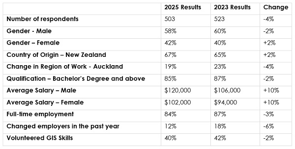
A total of 503 responses were received, providing a solid amount of data upon which conclusions could be drawn.
The data were collected anonymously and analysed by Rachel Summers, GIS Consultant and NZ Esri User Group member, with input from members of the GISS Committee.
The industry survey comprised 20 questions covering subjects such as demographics, education, employment status, location, salary range and professional membership.
The survey preamble pointed out that it was intended solely for those who identify as being part of the geospatial industry in New Zealand; that is, anyone who performs any of these roles:
- Captures, analyses, manages, presents and/or distributes geospatial data;
- Develops related equipment, software and/or services;
- Manages geospatial people, projects, systems and/or organisations; or
- Works in geospatial related education and/or research.
These criteria were adapted from specifications listed in the Spatial Occupation Description as defined within the Australian and New Zealand Standard Classification of Occupations.
Results
Some of the information gleaned from the survey results are as follows.
More than half of the respondents are under the age of 40, with the largest representation being in the 31-to-40-year-old category.
The 2025 survey attracted fewer respondents than that of 2023 but showed a small increase in the number of women represented — from 40.5% in 2023 to 42.3% in 2025.
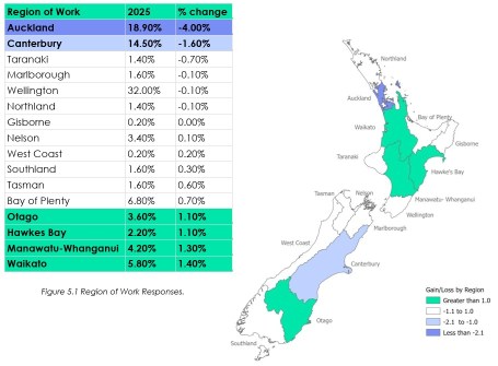
In terms of the locations where people work, the Auckland and Canterbury regions showed the largest losses, while the Otago, Hawke’s Bay, Manawatu and Waikato regions showed small growth.
Most respondents (81.6%) hold a bachelor’s degree, postgraduate diploma or a master’s degree. None of the respondents hold a postgraduate certificate.
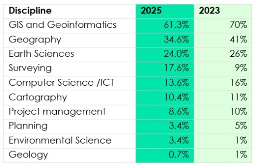
In terms of specialisms, the majority of respondents work in GIS, geography and Earth sciences (with many individuals having overlapping specialisms).
The majority of respondents, 84.1%, are engaged in full-time work, down slightly from 2023 (87%).
In terms of employment, the largest number (44.2%) work in the private sector, followed by local government (23%) and central government (20.3%), with self-employed, not-for-profit, academia etc making up the rest.
In terms of roles, the largest cohort (25%) describe themselves as GIS analysts, followed by surveyors (9.5%) and GIS consultants (7.8%), with various other roles making up the remainder.
The majority of respondents (68%) plan to still be in the industry in five years’ time, but this is drop of 5% from the 2023 survey.
There are plenty of other data points and details contained within the industry survey results, all of which offer a valuable insight into the state of the geospatial sector in New Zealand.


