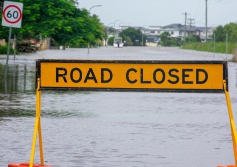
Queensland residents in the Douglas and Fraser Coast regions can now receive live flood alerts via select GPS navigation apps.
The Australian-first trial provides local drivers with critical, real-time warnings about flood impacted roads, hazards and automatic route diversions to help reduce risk and save lives.
The alert system is powered by an intelligent modelling tool developed by Brisbane-based company, FloodMapp.
Supported by NRMA Insurance’s Help Fund, the tool is being utilised by Douglas and Fraser Coast councils as part of the Queensland Flood Resilient Communities Program (QFRCP), a joint initiative designed to strengthen local disaster preparedness and reduce flood risk.
Despite the increasing threat of major flood events across the country, FloodMapp CEO and co-founder Juliette Murphy said Australia is lagging in its response to forecasting flood events.
“Flood events are volatile situations, where water can rise to threatening levels in a matter of minutes,” she said.
“We lose lives every year to the impacts of floods, often because people become trapped on flooded roads.
“These incidents can be significantly reduced with the accuracy and speed FloodMapp modelling provides,” Murphy added.
“This detail enables response teams to turn live forecasts into fast, safe, life-saving actions, in scenarios where every second can make a difference.”
A changing tide for disaster response
Councils participating in the QFRCP program have subsidised access to FloodMapp’s Prepare Solution for 12 months, which until now has been largely cost prohibitive for many local governments.
In addition, FloodMapp’s road impact analytics are now available for local residents who use the Waze navigation app (or Google Maps where Waze data is enabled), putting real-time, life-saving data in the hands of drivers to help avoid flood-impacted roads and surrounding hazards.
The flood alerts update as conditions change, and benefit from a live feedback loop to keep information current during fast-moving events.
Manager of Disaster Planning for Fraser Coast Regional Council, Brendan Guy, said Flood Mapp’s technology will improve the region’s flood planning and response.
“This trial will support faster and more informed Local Disaster Management Group decisions and enhance coordination between councils, emergency services and communities,” he said.