The TatukGIS Developer Kernel has been used to develop the new TreeGIS desktop 3D GIS front-end to the popular i-Tree urban forestry inventory and analysis tool.
i-Tree is developed by the USDA (U.S. Department of Agriculture) Forest Service to help communities strengthen their urban forest management and advocacy efforts by quantifying the structure of community trees and environmental services the trees provide. i-Tree is used by thousands in communities located around the world to plan and manage urban forests. Beyond i-Tree, TreeGIS can be easily modified to incorporate any urban forestry inventory.
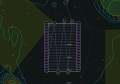
While i-Tree provides tools for gathering and reporting information about urban forests, it lacks tools for mapping this information. TreeGIS aims to fill this gap. Using the TatukGIS DK, an interface was developed that allows users to label trees, view tree attributes, select trees, and view summary information about selected trees.
TreeGIS also includes the ability to display the crown diameter of individual trees. Essentially this takes a one dimensional feature (tree location) and makes it two dimensional, enabling an easy answer to the question “Where are the trees, and how will they affect what’s around them?”
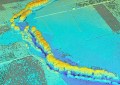
Taking advantage of the TatukGIS DK 3D mapping features, TreeGIS displays trees and surrounding terrain and buildings in three dimensions with just a click of a button. This ability, coupled with user-adjustable lighting effects, allows users to demonstrate to decision-makers different tree planting scenarios and their future effects.
Though not yet ported to iOS or Android, TreeGIS users can easily share their GIS data using GoogleMaps, BingMaps, or GoogleEarth with anyone with an iPhone or Android device.
As a DK-developed application, TreeGIS users can connect to (or store their tree data in) any TatukGIS-compatible database (including: Access, SQL Server, Oracle, Interbase/Firebase, Postgres, SQLite, IBM Informix, IBM DB2, MySQL, Sybase, ADV, & SAPD) and enterprise GIS database layer format (including: ArcSDE vector & raster, Geomedia SQL Server Spatial, Geomedia Oracle Object Model, IBM DB2 Spatial Extender, IBM Informix Spatial Datablade, MapInfo SpatialWare, Microsoft Spatial (Katmai), Oracle Spatial, Oracle Georaster, Oracle TIN, Oracle Point Cloud, PostGIS Spatial, Sybase SQL Anywhere Spatial, TatukGIS PixelStore). The speed, power, flexibility, and simplicity of SQL layers on SQLite is particularly appreciated.
According to TreeGIS developer Brian Brown, TreeGIS is unique in the i-Tree market, with few competitors: “The nearest competitor to TreeGIS is a solution based on ArcGIS Server, whereas we believe a desktop solution provides i-Tree users more flexibility and greater opportunity to leverage i-Tree tools. Never-the-less, the TatukGIS DK for ASP.NET edition gives us the possibility to also offer TreeGIS as an ASP.NET web server solution in the near future.”
TreeGIS is developed and owned by Mr. Brown’s company, TatukGIS Consulting (legally unrelated to TatukGIS), located in Dubuque, Iowa. TreeGIS is developed using the TatukGIS DK.VCL edition with the Embarcadero Delphi development environment.