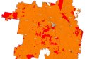
Intermap, provider of location-based information (LBI) solutions created from its uniform, high-resolution 3D digital models and orthorectified imagery of the earth’s surface, recently announced that its “Mapping the Basin: the Murray-Darling Basin Information Infrastructure Project” has been named winner of the Asian Geospatial Excellence Award – Environment Management. The award was presented during the 10th Annual Asian Conference and Exhibition on Geospatial Information, Technology and Applications on Oct. 17 in Jakarta, Indonesia.
“We’re honoured that our project in the Murray-Darling Basin has received this prestigious award,” said Todd Oseth, Intermap president and CEO. “This area is vitally important to the people of Australia as this region produces over one-third of the country’s food supply. Working closely with the Murray-Darling Basin Authority, we captured, aggregated, and fused important terrain data that can be used by the client in several geospatial related applications.”
The Asian Geospatial Excellence Awards recognise companies for exemplary usage of geospatial tools in various fields implemented in Australasia. Such fields include governance, infrastructure, public safety, utilities, design and engineering, environment, agriculture, mining and exploration, transportation management, business intelligence, insurance, and disaster management.
Intermap will be attending the spatial@gov Conference in Canberra, Australia from Nov. 15-17 and the 2011 Surveying & Spatial Sciences Conference in Wellington, New Zealand from Nov. 21-25.
For more information about Intermap and its NEXTMap datasets, visit www.intermap.com.