

On International Day of Women and Girls in Science, we speak with a researcher who’s fusing geospatial and AI.
International Day of Women and Girls in Science is an annual acknowledgement of the role that women play in STEM fields and an opportunity to focus awareness on the continuing gender inequality in those fields.
Because the sad reality is that we’re already a quarter of the way into the 21st century, yet the global statistics are still pretty dire. According to the United Nations:
- Women comprise only 35% of science graduates, even though young women are more likely than young men to go on to higher education (46% versus 40%).
- In 2022, just 31.1% of researchers worldwide were women.
- Women make up fewer than 2% of applicants for jobs in the quantum sector.
- In AI, only 22% of professionals are women.
Clearly, there’s a lot more to be done.
One way to encourage and help more women to enter (and remain in) STEM fields, is to showcase inspiring role models.
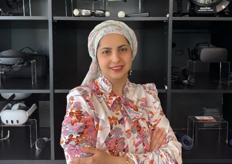
To that end, for this year’s IDWGIS we spoke with Ensiyeh Javaherian Pour, a PhD researcher at the Centre for Spatial Data Infrastructure and Land Administration at the University of Melbourne.
Javaherian Pour’s research involves developing a 3D spatial graph database that models how underground utilities are connected, translating the CityGML Utility Network model into a labelled property graph structure.
Conducted under the Resilient and Intelligent Infrastructure Systems Hub, and in collaboration with Emerson and South East Water, Javaherian Pour’s project injects 3D spatial intelligence into graph-based digital twins to enable better predictive maintenance and infrastructure management.
What attracted you to this field?
I gradually found my way into this area through my studies and research, where I became increasingly aware of a gap in how urban infrastructure is understood and managed. A lot of attention is given to above-ground assets, and there has been significant progress in using AI to detect, model and manage what we can see.
However, underground utility networks, which are essential to how cities function, often receive far less attention in both research and digital systems.
Most people have experienced the consequences of this at some point. Have you ever dealt with an unexpected service outage, or a road closure caused by damage to underground utilities during excavation?
These disruptions affect daily routines and urban mobility, and beyond that, they often lead to costly project delays and increased expenditure for service providers and governments. Together, these impacts highlight the real social and economic risks of not adequately representing and managing subsurface infrastructure.
Seeing these every-day and systemic challenges is what motivated me to focus my research on underground utilities. My work explores how geospatial methods and AI can be used to make these hidden systems more visible, easier to manage, and better integrated into digital representations of smart cities.
Ultimately, the goal is to support safer construction practices, more informed decision-making, and more resilient urban infrastructure.
Are there any attributes that are helpful to have in this field?
One of the most important qualities in the geospatial field is having a strong spatial mindset. Being able to think in terms of location, relationships and systems helps make sense of complex environments and provides a solid foundation for tackling real-world spatial problems.
Curiosity and a willingness to keep learning are also essential. Geospatial work rarely sits in isolation, and progress often comes from exploring ideas beyond one’s original training. Being open to learning from other disciplines and viewing new tools through a geospatial lens helps bring different approaches together in a meaningful way.
Finally, collaboration and communication play a major role. Many geospatial challenges are multidisciplinary, and working effectively with people from different backgrounds requires openness, adaptability, and the ability to explain spatial concepts clearly. These qualities help translate technical work into insights that support practical and informed decision-making.
What makes you most proud about your career?
What I’m most proud of is working on problems that people encounter in their everyday lives, often without seeing the complexity behind them. Issues such as service disruptions, safety risks or unreliable infrastructure affect communities regularly, and being able to contribute research that helps governments and industry address even a small part of these challenges is very rewarding.
I also find it motivating to know that this work can support the development of smarter and more resilient cities. Improving how infrastructure systems are digitally represented and understood can help inform better decisions and safer practices, particularly as digital twins become more widely used in planning and infrastructure management.
Knowing that this research can provide a foundation for future work, and that others may build on it to create broader benefits for cities and communities, is something I value highly.
We need more women in this sector. Do you have any ideas?
I think one of the most effective ways to encourage more women into the geospatial sector is through early exposure and visibility. Many people are simply not aware of what geospatial careers involve or how widely they are applied, so introducing these ideas through education, outreach, and real-world examples can make a real difference.
Providing opportunities such as introductory workshops before university, along with mentorship programs, can help clarify early career pathways and make the field feel more accessible. Creating spaces where people can explore geospatial topics without pressure allows individuals to make informed choices based on their interests and strengths.
Ultimately, improving awareness and support at an early stage helps broaden participation in a natural and inclusive way.
What would you say to women who are considering a career in geospatial?
I would say that geospatial is a broad and flexible field with applications across many areas, from infrastructure and planning to environmental analysis and emerging digital technologies. It offers opportunities to work on real-world problems and see the impact of your work in practical settings.
For anyone considering this path, it can be helpful to explore the field through short courses, projects or internships. and to speak with people already working in the sector. Building strong foundational skills and staying open to learning as the field evolves can go a long way.
Most importantly, choosing geospatial because it aligns with your interests and strengths makes it a rewarding and sustainable career choice.
Is there anything else you would like to add?
I would add that the geospatial sector is evolving rapidly, and this creates exciting opportunities for both research and practice. As technologies and applications continue to expand, collaboration between academia, industry, and government will be increasingly important.
Supporting inclusive, innovative environments will help the sector continue to grow and deliver meaningful benefits for cities and communities.
Further reading:


