

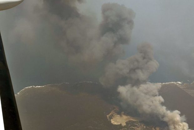
Real-time maps of the Kangaroo Island fire-front created using innovative new technologies developed by SA company FireFlight and deployed in support of the Australian Army have been a boon to relief and recovery operations’ teams on the ground in Kangaroo Island.
FireFlight’s aerial mapping system was deployed in a single engine Piper aircraft flown over fires at 10,000ft, and the images taken were used by members of the Australian Army to plan and execute recovery and relief operations, in support of emergency services and local communities.
Thanks to specialist thermal imaging cameras, high precision GPS and advanced data processing software, FireFlight’s fire mapping system can provide real-time maps of wildfires as well as details of post-fire hotspots, underpinning a strategic and efficient plan to fight fires and aid recovery.
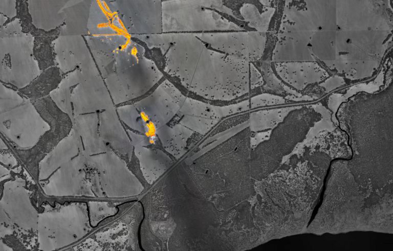
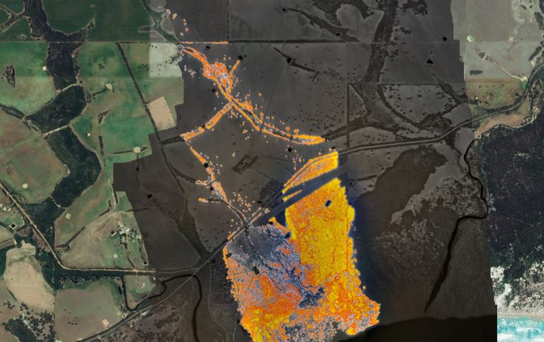
On 9 January 2020, the Kangaroo Island fire was pushed towards Vivonne Bay. The town and nearby region had already been evacuated. The two images show the fire three hours apart, at 1400 (2pm) and 1700 (5pm) local time. These images show the extent to which the fire moved and grew in that short period of time.
The FireFlight system uses thermal sensors connected to a GPS and computer, and mounted in light aircraft.
Founder and CEO of FireFlight, Dr Paul Dare, began developing the fire mapping technology 15 years ago, and has commercialised it after participating in the Venture Catalyst Space program at UniSA’s Innovation & Collaboration Centre.
“During my time as a volunteer firefighter, I could see the impact that climate change was having on the frequency and severity of bushfires in Australia and overseas, which is when I decided to use my skills as an airbone imaging specialist, to develop a fire mapping system,” Dr Dare says.
“The invaluable mentorship and support I received as part of the Venture Catalyst Space program, has supported the development of a commercialised product that’s already being used to fight Australia’s bushfires.”
How the FireFlight system works
FireFlight is an airborne fire mapping system that provides real-time fire maps and post-fire hotspot maps to fire managers, fire agencies and other relevant stakeholders. The FireFlight system is cheap to deploy and easy to use. FireFlight systems are shipped from Australia and operated by local pilots in fire danger regions worldwide.
The FireFlight system uses thermal sensors connected to a GPS and computer, and mounted in light aircraft. The flight management software that ties the system together provides pilot navigation, camera control, data communication and real-time image interpretation. Software on ground-based servers receives the fire maps from the aircraft, combines them with other useful geographic information, and makes the result available on a secure website.
The traditional approach to fire mapping is to have a small number of high-value assets: large aircraft with imaging systems worth hundreds of thousands of dollars. FireFlight operates multiple low cost fire mapping systems, geographically spread over a wide area, which can be more effective than a few expensive fire mapping systems with limited geographical coverage. And by having many more systems available, the impact of system or aircraft failures is greatly reduced.
Technology deployed to Californian, Canadian hotspots
The company was now finalising technology leasing contracts with a Californian company based outside of San Francisco that works with the state’s fire and government agencies, along with another company in Canada.
Both countries are approaching their own fire seasons with Dr Dare saying the technology being commercialised through FireFlight can be used day or night and can also detect remaining hotspots once fires pass.
“We are leasing to clients so that at the end of the fire season we can get the system back in and have it refurbished and ready for the next fire season, technology is moving so fast we need to be constantly upgrading,” Dr Dare said.


