Accessible through desktop and mobile, OS Maps has become the first choice amongst those wishing to get outside more to discover and explore Britain, helping users to create new adventures, discover walks and navigate routes as they go.
As a result of the Covid-19 pandemic and subsequent UK lockdowns, OS Maps significantly grew in popularity. The app saw a 78% increase in subscribers with local searches of green space mapping, such as parks, public open spaces and urban cycle networks increasing by over 1,000%.
The UK’s most popular outdoor navigation app has over 3.5 million users in Great Britain and allows people to navigate with the most up-to-date mapping, as well as providing access to over 4 million routes covering 30 million miles. During 2020 OS Maps became a vital tool in helping individuals and families discover walks, parks and green spaces in their neighbourhoods.
Coming to Australia
OS is looking to expand on the success of OS Maps by transporting its award-winning app over 14,000 kilometres away to Australian soil.
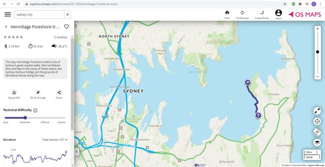
OSMaps.com shares the same look, feel and functionality as its British counterpart, and will provide a similar service for the whole of Australia.
The app utilises cutting-edge technology, including 3D mapping, and includes accurate and detailed mapping data from state governments across Australia. In addition, the new app contains ready-made routes provided by a range of partners including New South Wales National Parks and Wildlife Service.
OS’s managing director for leisure Nick Giles said: “It has been a big challenge to launch an app in a new market while we’re going through a global pandemic.
“From the research we’ve conducted, we discovered how Australians share similar behaviours and habits around enjoying the outdoors as we do in Great Britain, with an insatiable appetite for living outdoor active lifestyles much like ourselves.
“We believe that outdoor enthusiasts in Australia are not served well enough by the market for discovering and planning walks, runs, cycles or hikes both on and off the beaten path.
“OSMaps.com will give them the ability to plan their own routes or discover and download thousands of ready-made ones all over the country.”
This international expansion is the latest phase in OS’s strategy for the leisure market.
Mr Giles added: “Australia is the first country we have targeted and over the next year we aim to roll out in other nations around the world including Canada, the United States and New Zealand.”
Ordnance Survey, Great Britain’s mapping agency, will celebrate 230 years in July 2021. Over the last two centuries, OS has continuously evolved, from military origins to commercial operations both in the UK and globally. During this time the organisation has been at the forefront of innovation and in recent decades transforming from paper map producers to leading the way with digital maps and apps.
OS has an ambitious plan for its digital mapping products for 2021 and beyond, including new apps designed to inspire and act as storied guides for the outdoors.
Longer-term, OS is also investing in augmented reality gaming all with the ambition of helping more people to get outside more often.
Mr Giles said: “2021 is building on a year where we have seen the nation connect with the outdoors. We are seeing people wanting to learn and discover more about the landscape; they want to be inspired with enhanced experiences of what the outdoors has to offer, whether this is on their doorstep or further afield.
“The benefits of regular exercise are well documented and enhance both physical and mental wellbeing.
“At OS we are proud to be playing our part in helping the nation to get outside more often.”
Stay up to date by getting stories like this delivered to your mailbox.
Sign up to receive our free weekly Spatial Source newsletter.